
Last week on Wednesday, I met some of my hiking buddies at Chaney Trail.
It was a first time for the entire group hiking to Dawn Mine.
Since I've been chasing waterfalls, I decided to make it a loop hike saving the falls for last.
The trail was restored about a year ago by the Restoration Legacy Crew. They are continually maintaining it which makes it very nice to follow an easy path through the canyon.
They have built impressive staircases and rock walls along the way.
The stream was definitely flowing since the last storm. There were alot of mini waterfalls and cascades. To add, there were many water crossings but we managed to keep our shoes dry.
The only time I got my feet wet was when I jumped into the pool of water at the Lower falls.
The canyon was very lush and green. It was so very scenic. The skies were blue and the clouds were spectacular!
After checking out the mine we hiked back to the road passing by the Cape of Good Hope, then descended the trail again back to our cars.
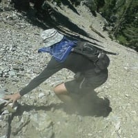
We proceeded to Millard Falls which was flowing nicely. Then we climbed to the top of the falls with some rope assistance. The use trail is steep, narrow and a bit sketchy.
The views at the top of the falls were magnificent!
I also found a few mushrooms along the way.
Stats: 9 miles, 1800' gain
MILLARD FALLS & DAWN MINE
-
Girl Hiker

- Posts: 1318
- Joined: Fri Apr 04, 2014 7:46 am
More pics
Hey Jeff, let me see you do this jump lol
Hey Jeff, let me see you do this jump lol
-
CrazyHermit

- Posts: 343
- Joined: Mon Sep 07, 2015 1:03 pm
Here's some old shots of the in and around the mine before two of them were gated. There are three of them in all, one is fifty feet above the main, the third is about 1000 feet upstream. This was back in the day when I had a cheap camera and used a flash to take terrible photos. In the old days when the Mt. Lowe Railway was running they would stop the train and allow passengers to walk down to a "fake" Dawn Mine from the Dawn Mine Station. Otherwise it would have taken ages for them to walk all the way into the canyon and back.

Great shot there!Girl Hiker wrote: ↑ Hey Jeff, let me see you do this jump lol
"Argue for your limitations and sure enough they're yours".
Donald Shimoda
Donald Shimoda