
I’d hoped to do this route when Kurt and I were walking from his place in Glendale to the Magic Mtn. area, but the Gold Canyon Trail, though it appears on the Tom Harrison map, seemed sketchy. I wasn’t even sure you could even get to it without trespassing. It starts at Big Tujunga Canyon Rd., about 3 miles from Sunland at the first bridge, where Gold Canyon meets Big Tujunga Canyon. In the past it began at the southwest corner of the bridge. A gentle slope took you down to the creek which you crossed, if the water was low enough. You then headed up while keeping right, and after 200 feet branched off of Tujunga, up into Gold Canyon.
That older approach is shown on some maps but the land on eastern side of the bridge is privately owned, and now a gate blocks the trail. That’s not a show stopper though, because instead you can start from the northwest corner of the bridge (which faces Gold Canyon) drop down, take a short use trail on the right down to the Tujunga creek bed, cross it, and then follow the same route, veering right to enter Gold Canyon. The area right under the bridge isn’t especially nice, and must host occasional drinking parties, but it’s soon behind you.
Last year my wife and I explored that approach and walked about a mile of the canyon. There wasn’t really much trail but the going was pleasant enough, sort of hop-scotching up through the rocks and sand. The canyon walls and nearby hills are scenic. It feels slightly remote...maybe in part because few people go there. But further up, the trail hangs a left and switchbacks up towards Gold Canyon saddle. I imagined that part would be badly overgrown and might be confusing or even unsafe. So Kurt and I walked from Big TJ to Little TJ on fire roads instead, and Gold Canyon trail went onto my wish list.
Dima and I talked about that route and I asked him about going a couple of times; on the 9th our schedules coincided and we headed up there with 2 cars. For a slightly dubious route like this, one couldn’t ask for a finer hiking buddy. As I’ve gotten into hiking these mountains over the last few months he's shared info, hiking know-how, and one-with nature-wisdom; a calm San Gabriels guru. I hiked in the Himalayas with holy men who walked a thousand miles with few provisions and no maps, somehow never making a wrong turn. Dima sometimes reminds me of those men (except that most of them went barefoot).
We left a shuttle car at the Gold Creek Trailhead, drove over to bridge on Big Tujunga, and after a quick scope-out, began walking. After missing the right fork to Gold Canyon (my bad, having been there before) we back-tracked a few minutes, swung left, and began the easy climb. This time a little water trickled down the creek bed, but not enough to matter. After 1.3 miles of easy walking up the canyon, we saw faint traces of trail switchbacking up the left hillside. Dima used a lopper to start clearing some of the brush and we headed up. A few sections were clear, but the climb was very brushy and he did lots of cutting. It looked like no one had walked this trail for quite a while. Before long we realized it'd be faster and easier to go straight up the ridge, which was not very steep and reasonably clear. About halfway up we started getting nice views of Mt. Lukens, and the higher peaks to the east. After two hours we reached the Yerba Buena fire road, just past a small hill, and stopped to eat.
According to Strava this hike burned 1650 calories, and last year I decided that on a walk like this I can eat whatever I want, in any quantity. Porto’s Bakery has an efficient in-car pickup system, and stopping there for goodies has become my favorite pre-hike ritual. Usually I'll pack a sandwich, an empanada, a scone, some cookies, and a few extra things for good luck. Dima’s boiled egg and tortilla (about 150 calories) was more like the no-nonsense meal a Thai Monk might be given while gathering alms. (Some of his strength may come from Above.)
We swung west on the Yerba Buena fire road and after a little more climbing, stopped again to enjoy the views from a hilltop water tank. From there a short descent led us towards Oak Spring Trail. We bushwhacked for a few minutes as a shortcut and passed a large old odd looking tank or container boxed in by barbed wire. No idea what this was. The spring was a little further down — a shady, scenic little spot with some big nice trees -- a rare sight in these hills.
A mile or so past the spring we traversed left at a saddle, to re-visit the the 1949 P-51 crash site on Peak 2602 that was discussed here in 2019. Last year I visited the southern part of the site, where some engine pieces and electrical assemblies lie in a small gully. This time I wanted to see the larger wing and stabilizer pieces scattered north of the peak. The original accident report that Dima posted suggests that some of these pieces may have broken away from the fuselage soon after the plane began its fatal dive:
Between 1515 and 1530 PST , according to the only known witness, this aircraft was observed to dive out of the overcast over the scene of the accident. The accompanying noise was described as similar to jet-type aircraft which indicates power on and high velocity. The angle of dive was estimated at between 60 deg. and 80 deg. According to the witness the right wing left the aircraft after it had dived one-third of the distance from the base of the clouds to the ground, described by the witness as a total distance of 1500 ft. (The 1500 ft described is subject to question as one pilot reported the bases of the cumulo-nimbus at 12000 ft MSL, the Ranger at Mendenhall Station three miles NE of the scene reported 1000 ft MSL.) The aircraft struck the ground at the 2500 ft level. This error in altitude or the judgement of the distance is possible in that the aircraft, traveling at 600 MPG would traverse the distance from the base of the clouds at 12000 ft. to the ground level of 2500 ft. in a matter of 12 seconds.) Immediately after the first wing tore off the aircraft the other wing left the fuselage and the aircraft seemed to disintegrate, according to the witness, with the engine and cockpit section striking the ground.
The location of major parts of the aircraft relative to the direction of flight leads this board to conclude that the aircraft was in an inverted position in the dive and that the left wing broke loose from the fuselage first rather than the right wing as described by the witness. It is also concluded that the empennage was torn loose prior to impact with the ground. This conclusion was reached due to the relative condition of this section and its position on the ground plus the location and condition of the oxygen tanks on the scene. The engine and cockpit section struck the ground with such velocity that due to its condition no investigation could be made relative to the positions of controls and power settings. It was ascertained however that the canopy was closed at the time of impact with the ground...
Many pieces are scattered north of the peak; some 5 or 6 feet long. I know little about planes but they looked like wing and empennage parts. It was really interesting to walk around and examine all that stuff, but the sun was starting to set. Another 20 minutes of bushwhacking led us back down to Oak Spring trail, and the trailhead.
This was a satisfying day and I was glad to finally walk the Gold Canyon trail. It's not all that special, and for most people there would be little reason to fight their way up it, but I’d been curious for a while, and it’s was satisfying to finally hike it. https://www.strava.com/activities/4736387092
Big Tujunga to Gold Creek Road via Gold Canyon Trail and the P-51 Crash Site
-
David Martin

- Posts: 85
- Joined: Sun Nov 08, 2020 7:08 pm
-
- A holy man I hiked with in 1982 near Ulleri, Nepal on my way to the Thorung La Pass. He had walked about 400 miles from Lucknow, India.
-
-
-
-
- We couldn't figure out what this thing was
-
- Break time
-
- Looking east from Yerba Buena, with Mt. Lukens on the right
-
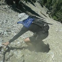
- Starting up the hill from the bottom of the canyon
-
- We accessed the trail from this corner of the bridge

Yeah, what David said.
The initial part, in Big Tujunga is a bit overgrown, but not too bad. Gold Canyon is wide-open and easy to walk. The trailbed on the climb up is decent, but overgrown. We cleared the lower sections until an easier ridge option opened up. A day or two of dedicated work can clear this whole thing right up.
Now the photos.
From the climb up to Yerba Buena ridge you can see the Gold Canyon headwall. It's quite dramatic:


I think AW climbed up or down this thing at some point. The saddle on the left is Gold Canyon Saddle, and the water tank that's up there.
We connected to the road on a ridge, a bit S of where the trail comes out. I walked back to the trail end to see what it looks like. It's overgrown, and there's a sign:

It's only closed to motor vehicles! According to OSM, if I walked a bit further N on that road I'd hit a landslide: https://www.openstreetmap.org/#map=17/3 ... -118.29537
Has anybody been there recently? Is there actually a road-blocking landslide, or is that data old? I can't tell from the aerials.
Our high point was the water tank SW of point 3892. It's labeled:

The weird water-trough thing near the top of the Oak Spring trail:

What is it? It's surrounded by barbed wire, so it's not intended for any animal to enter. And the Oak Spring area is nice:

It's pretty much the only spot with trees in this whole area.
I think it's this: https://caltopo.com/map.html#ll=34.2995 ... magery&n=1
The trough is the white rectangular thing.
The trough is the white rectangular thing.