Guess the trail name!

Trip planning, history, announcements, books, movies, opinions, etc.
Post Reply
User avatar
Sean
Posts: 3748
Joined: Wed Jul 27, 2011 12:32 pm

Post by Sean »

Rules:

1. Post a photo of a trail in SoCal or the Sierras. Name the range it's in. If it's not in the San Gabriels, you might want to give a small hint.
2. Pick a stretch of the trail with a recognizable feature or two, such as distinctive terrain, a sign, a cabin, historic ruins, a waterfall, a peak, etc.
3. Whoever correctly guesses the trail name gets to post the next photo--or say "pass," in which case anyone else can post the next picture.

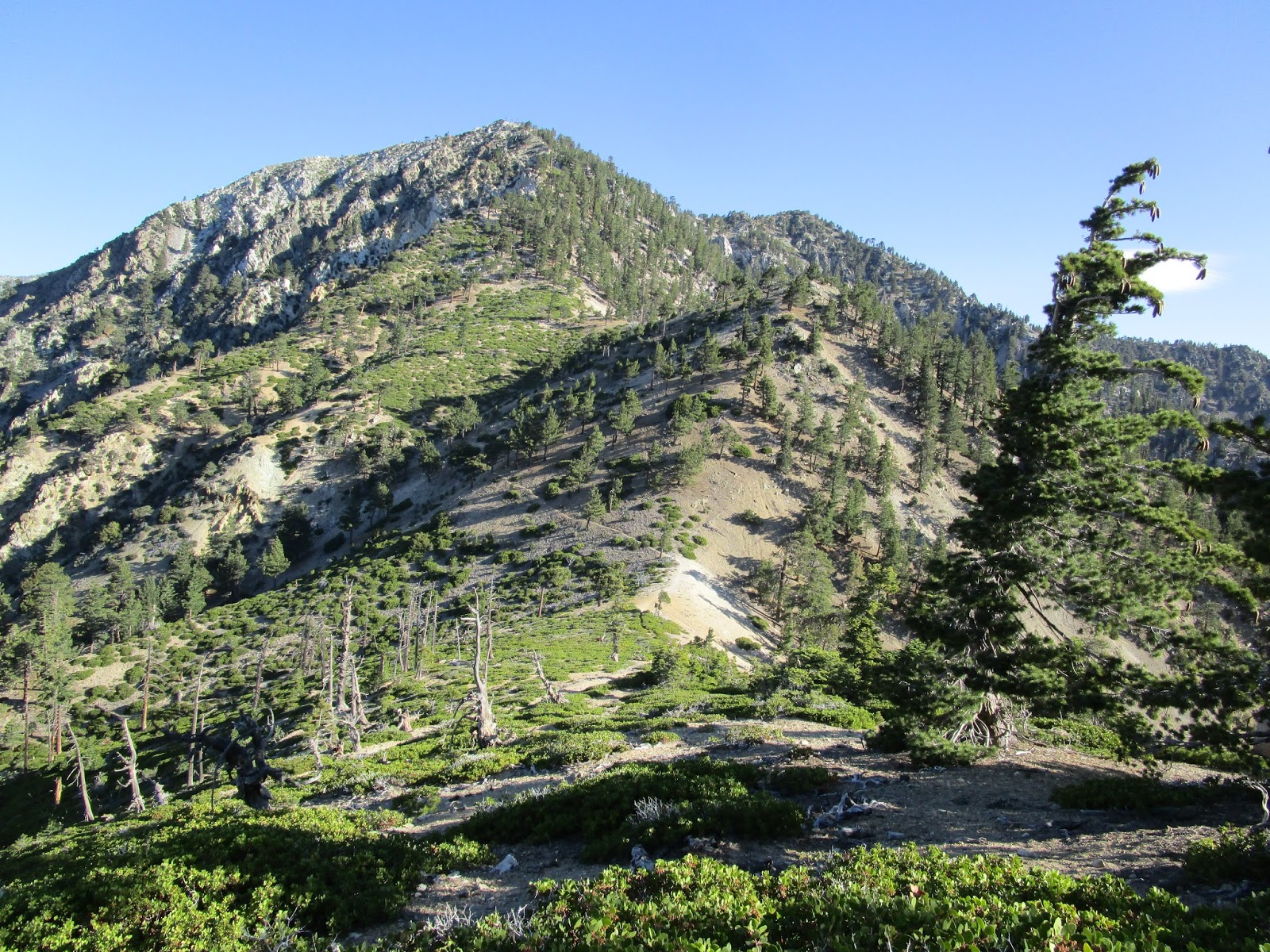
I'll start with one from the San Gabriel high country in 2015. Guess the trail name!

IMG_5030.JPG


IMG_5030-001.JPG
User avatar
Elwood
Posts: 612
Joined: Fri Aug 15, 2008 5:23 pm

Post by Elwood »

8W32 Dawson Peak Trail
User avatar
dima
Posts: 1319
Joined: Wed Feb 12, 2014 1:35 am

Post by dima »

Is this sign up on the Pine-Dawson saddle?
User avatar
Sean
Posts: 3748
Joined: Wed Jul 27, 2011 12:32 pm

Post by Sean »

dima wrote: Is this sign up on the Pine-Dawson saddle?
It was in 2015.
User avatar
Sean
Posts: 3748
Joined: Wed Jul 27, 2011 12:32 pm

Post by Sean »

Elwood wrote: 8W32 Dawson Peak Trail
That's the trail going off to the right. What trail are we on?
User avatar
Elwood
Posts: 612
Joined: Fri Aug 15, 2008 5:23 pm

Post by Elwood »

7W05.2 affectionately know as the north devil's backbone trail.
User avatar
Sean
Posts: 3748
Joined: Wed Jul 27, 2011 12:32 pm

Post by Sean »

Elwood wrote: 7W05.2 affectionately know as the north devil's backbone trail.
Yes!
User avatar
Elwood
Posts: 612
Joined: Fri Aug 15, 2008 5:23 pm

Post by Elwood »

Sticking with Sean’s rules, I’ll “pass” ‘til I can get at my trove of trail pictures.
User avatar
HikeUp
Posts: 3846
Joined: Thu Sep 27, 2007 9:21 pm

Post by HikeUp »

2010...
IMG_7328.jpg
User avatar
Elwood
Posts: 612
Joined: Fri Aug 15, 2008 5:23 pm

Post by Elwood »

This trail is in the San Gabriel Mountains. What's the trail and where is the picture taken from?
IMG_0378.png
User avatar
tekewin
Posts: 1194
Joined: Thu Apr 11, 2013 5:07 pm

Post by tekewin »

Cucamonga Peak Trail from Joe Elliot Campground.
User avatar
Elwood
Posts: 612
Joined: Fri Aug 15, 2008 5:23 pm

Post by Elwood »

Well done tekewin, 7W04.5 indeed. Your turn sir.
User avatar
tekewin
Posts: 1194
Joined: Thu Apr 11, 2013 5:07 pm

Post by tekewin »

We'll stay in the San Gabriels... what trail and location?

Image
User avatar
Elwood
Posts: 612
Joined: Fri Aug 15, 2008 5:23 pm

Post by Elwood »

Three 'T's towards Telegraph 7W04.4 FYI I compared this picture to some of mine BEFORE noting the filename of your linked picture.
User avatar
tekewin
Posts: 1194
Joined: Thu Apr 11, 2013 5:07 pm

Post by tekewin »

Correct! An easy one, and I'll be careful with the file name next time (doh!). Back to you.
User avatar
Elwood
Posts: 612
Joined: Fri Aug 15, 2008 5:23 pm

Post by Elwood »

Here's one, definitely in the San Gabriel's:
IMG_7063.png
User avatar
tekewin
Posts: 1194
Joined: Thu Apr 11, 2013 5:07 pm

Post by tekewin »

This is just a guess. Is it 10W04 south of Three Points?
User avatar
HikeUp
Posts: 3846
Joined: Thu Sep 27, 2007 9:21 pm

Post by HikeUp »

I'm gonna say 10W05 on the way up to Waterman from Hwy 2/Buckhorn, with a view of East Twin.
User avatar
Elwood
Posts: 612
Joined: Fri Aug 15, 2008 5:23 pm

Post by Elwood »

This was from a Twin Peaks / Waterman hike, so the view is looking back towards East Twin on 10W04. Well done tekewin. I guess you're it again. Hike Up, I hadn't quite turned onto the peak trail yet no boots on 10W05 when this picture was taken.
User avatar
tekewin
Posts: 1194
Joined: Thu Apr 11, 2013 5:07 pm

Post by tekewin »

This one is harder, in the Santa Ana Mountains. What trail?

Here is a hint. It starts at the Morgan trailhead on South Main Divide Road.

Image
User avatar
Uncle Rico
Posts: 1394
Joined: Thu Mar 20, 2008 7:48 pm

Post by Uncle Rico »

Random guess based upon clue: San Mateo Peak Trail.

Never been there.
User avatar
tekewin
Posts: 1194
Joined: Thu Apr 11, 2013 5:07 pm

Post by tekewin »

Uncle Rico wrote: Random guess based upon clue: San Mateo Peak Trail.

Never been there.
Right on! It's a short and easy 4 miler, but nice views and varied terrain.

Your turn, Rico.
User avatar
Uncle Rico
Posts: 1394
Joined: Thu Mar 20, 2008 7:48 pm

Post by Uncle Rico »

Ok, this is back in the San Gabes. No distinctive features per se, but I'm pretty confident y'all can get it.

8.1_Thumbnail.JPG
User avatar
Sean
Posts: 3748
Joined: Wed Jul 27, 2011 12:32 pm

Post by Sean »

Is it in the Mt. Wilson area? Maybe the Gabrieleno on the north side?
User avatar
Uncle Rico
Posts: 1394
Joined: Thu Mar 20, 2008 7:48 pm

Post by Uncle Rico »

A bit north-northeast of Wilson.
User avatar
HikeUp
Posts: 3846
Joined: Thu Sep 27, 2007 9:21 pm

Post by HikeUp »

Rim Trail (11W28)?
User avatar
Uncle Rico
Posts: 1394
Joined: Thu Mar 20, 2008 7:48 pm

Post by Uncle Rico »

Further north.

My "bits' are bigger than yours. ?
User avatar
Sean
Posts: 3748
Joined: Wed Jul 27, 2011 12:32 pm

Post by Sean »

Devil's Canyon Trail looking southish.
User avatar
Uncle Rico
Posts: 1394
Joined: Thu Mar 20, 2008 7:48 pm

Post by Uncle Rico »

Winner, winner, chicken dinner.

You up.
User avatar
Sean
Posts: 3748
Joined: Wed Jul 27, 2011 12:32 pm

Post by Sean »

This is in the San Gabriel foothills from 2012.

SAM_2221.JPG
Post Reply