
[TLDR: Attempted to hike nonstop and self supported from Angelus Oaks over Gorgonio, south on PCT, up Jacinto to Idyllwild. Made it 70 miles out of 90 before having to bail due to leg pain, stats and gallery at bottom.]
Route and planning
This hike was done two weeks ago, but I'm just getting around to finishing and posting a report now. After completing the San Gabriel Death March back in November, I wanted to do something similar again. Since that trip went over Baldy, I liked the idea of doing something that included the other two of the three big summits in SoCal, San Gorgonio and San Jacinto. So after looking at the map for a while I decided I would attempt to hike nonstop from Angelus Oaks up the San Bernardino Peak Trail to the ridge, follow that east to the San Gorgonio summit, go down Sky High Trail to Fisk Creek and join the PCT, take that south to Snow Creek, hike up to Fuller Ridge, take that to the San Jacinto summit, then hike through Wellman Divide and Saddle Junction, finally down to Humber Park on the edge of Idyllwild. The two maps I looked at didn't quite match up in miles and such, but the total distance is a little over 90 miles and somewhere around 17,000 feet of elevation gain.
The distance is significantly longer than the 47.4 miles I did on the SGDM (and thus by far the longest I've ever attempted), but the overall elevation gain is actually pretty comparable. Unlike last time, this route would also be entirely on trail, so I wouldn't have to worry about any bushwhacking, scrambling, or route finding. I also decided to do this one entirely self supported, partially as a new challenge for myself, and partially to require less work from my lovely and supportive wife. The plan was to cache supplies for myself ahead of time in several locations, as well as filtering water along the way and traveling light. I would drive myself to Angelus Oaks on Wednesday afternoon and start, reach my first cache Thursday morning. From there I would make it up Fuller Ridge some time late that night with two more caches along the way, then summit Jacinto and reach Idyllwild late Friday morning or early Friday afternoon. My wife would be hanging out in Idyllwild starting Friday morning and able to see my progress via InReach updates then meet me at the finish point of Humber Park. Once she picked me up we would spend the night in Palm Springs (Idyllwild was too expensive!) and pick up the car at the starting point on Saturday after a long sleep and a big brunch.
Section 1: Angelus Oaks to San Gorgonio Summit
I started at 3pm on Wednesday afternoon with perfect weather and feeling good. The route starts with a moderate but steady climb right away, beginning just below 6k at the trailhead and reaching San Bernardino Peak at 10,649 feet in about 8 miles. I saw a group of hikers on their way down shortly after I began, and one solo hiker descending near Limber Pine Springs (which had a small but steady flow), but nobody else until I joined the PCT early the next morning. The hike up to the ridge was pleasant but uneventful, but the moment you finally get up to the ridge and have that huge view to the east with Gorgonio, Yucaipa Ridge, and Jacinto in the distance is always spectacular. It also did a good job of showing how far away my goal was! I was feeling strong and it was still light out, so I made the minor detours off the main trail to tag the San Bernardino, San Bernardino East, Anderson, and Shields Peak summits. With the sun rapidly setting on my way down from Shields, I stopped to put on my gloves and extra layers, as well as get out my headlamp. About halfway between Shields Peak and Dollar Saddle it became fully dark, with a fantastic waxing crescent moon rising behind me. I reached the summit of Gorgonio just after 10pm and as usual, it was very windy. On the plus side, they sky was clear and the stars were awesome. I only found a small piece of the summit sign, I don't know where the rest of it went but wasn't in the mood to take time looking around with the cold wind blowing.
Section 2: Gorgonio Summit to Fish Creek/Pacific Crest Trail
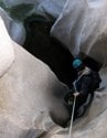
I was a little concerned about the Sky High Trail section because the most recent info I had found said there was still snow across the trail in places. The report was over a week old so I was hoping most of it had melted, but I was carrying microspikes just in case. Luckily the snow had melted significantly. The one section I had to fully cross was only about 30 feet and in a nearly flat section, the others generally just came to the edge of the trail and could be skirted or easily crossed. I never needed my spikes and it would have been nice to save the weight, but bringing them was still the right call just in case. Shortly before Mine Shaft Saddle the trail passes the wreckage and plaque for a C-47 plane wreck, I haven't been on that section in a long time and forgot how large the wreckage was! Past the saddle the trail deteriorates a bit with some minor erosion, rock fall, and vegetation, but is still easy to follow. At the first crossing upstream from Fish Creek Meadow I stopped to filter water and was quite pleased with my new combo of a Sawyer filter and CNOC Vecto water bladder, which I had randomly stumbled upon shortly before the trip while looking at Hikin' Jim's blog. Continuing past the meadow I saw a couple dozen pairs of eyes watching me in the dark. It looked a little spooky, but I'm pretty sure it was just deer. I lost the damaged trail in the dark shortly before the Fish Creek Trailhead and road, luckily I was able to make up the difference with GPS. This would have been the ideal spot for cache number one as it was a little over 25 miles into the route, but the trailhead is still closed from the Lake Fire so I wouldn't have been able to drive there to stash supplies. From there it was a short walk on the dirt road to where it meets the PCT.
Section 3: PCT to Whitewater Preserve
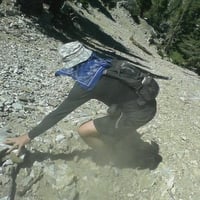
As soon as I reached the PCT around 1:30am I saw my first person since Limber Pine Springs in the form of a tent right at the junction. I thought most people would have passed this area by now, but I guess it's more of a rolling start and I probably saw 100 PCT hikers over the rest of the day. This section is mostly long and gradual descent, I would occasionally pass groups of tents along the way and do my best to walk quietly. As morning sun came up I would pass rustling tents of hikers waking up, then people out and packing up, and eventually all the hikers going north as I continued south. The trail follows a stream with a healthy flow, so I was able to stop and filter a little more water along the way. I had been trying to stretch my food as long as possible in this section because my first supply cache wasn't until 47 miles into the route, eating the last of my food close to the 40 mile mark. It wasn't a problem, but it would have been nice to carry a little more because I was pretty hungry when I finally reached my first cache. At this point I was definitely feeling the miles and my lower legs were getting a little sore, but I felt ok overall. The first cache was buried uphill from the road into the Whitewater Preserve visitors center, this required a one mile detour from the trail, but was the closest place I could drive to when I dropped it off. Inside was 4.5L of water, clean socks and a shirt, and a variety of foods including Pop Tarts, Clif Bars, Shot Bloks, Cheese Its, and ginger snap cookies. I had taken short breaks along the way, but this was the first long one as I relaxed a little, changed clothes, ate a bunch of snacks, refilled water, and dropped off my no longer needed microspikes.
Section 4: Whitewater Preserve to Snow Creek
Once I started moving again I realized my lower legs were getting increasingly sore and things started to get tough. At this point I had passed the total mileage of the San Gabriel Death March, so everything past this would be the longest I'd ever hiked in one go. I still had roughly half the distance and elevation gain remaining, so while I wasn't feeling 100% I definitely felt determined and able to keep going. Shortly after rejoining the PCT from Whitewater the trail starts climbing again and I could feel myself slowing down, as well as some aching in my lower legs. At this point a high wind also started up. After descending the high point of this section and entering the wide open and flat valley, the wind got even stronger. If I wasn't in a stable position, some gusts threatened to blow me over! The trail passed a wind turbine farm, turns out they built all those things in this valley for a good reason. At a sheltered spot I called my wife to check in, putting a positive spin on how things were going and discussing plans for pickup the next day in Idyllwild. PCT hikers had thinned out significantly in this section, but as I passed under I-10 there were some trail angels with supplies and a few hikers hanging out there for shade and wind protection. The last few miles of this section were pretty painful for my lower legs and left knee, despite being pretty much flat. As I got closer to cache number two near Snow Creek I found myself half hoping that somebody had found and pilfered my supplies to give me an excuse to bail. My stash, buried next to a large cholla and disguised with some clean toilet paper to discourage others from digging there, was intact, so I took a fairly long break here to resupply and rest.
Section 5: Snow Creek to bailout
The aching in my legs had been getting increasingly sharp and painful, I found it a little difficult to even stand back up to get moving again, but wasn't ready to give up. Despite slowing down and hurting over the last few hours, I was still not that far off my original goal pace, so I figured I had plenty of time if I just went slow and steady. The next section was the big climb, from 1,200ft to 7,600ft at the Fuller Ridge trailhead. The first section from where the PCT hits Snow Creek is actually the paved Falls Creek Road, which is surprisingly steep for a paved road! After passing a gate and continuing up the road a little bit the actual PCT starts up again at a spot with some large boulders and a water fountain for hikers. It was now 5:30PM and there were several people here already settled in for the night, so I tried to go by without limping or looking like I was about to die. Unfortunately the pain in my legs was noticeably worse at this point and the climbing wasn't helping. When I sat down for a break it was even more painful and difficult to get back up than the last time. The high winds weren't helping either, with high gusts requiring me to brace and tighten my muscles, causing even more pain.
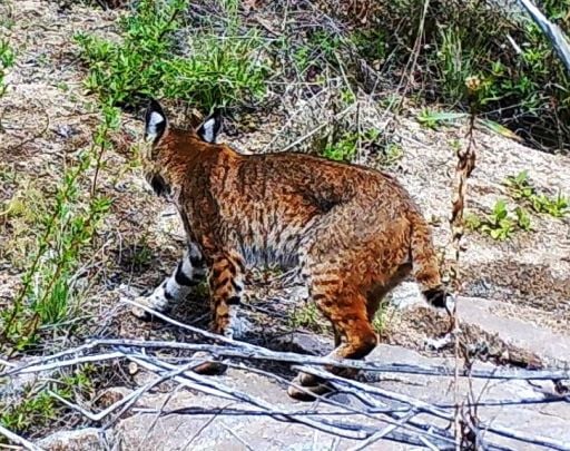
After two miles of this I realized I had to bail at about 7PM. My legs hurt enough that I wasn't sure I could make it ten more miles to the trailhead and next road access, not to mention the 5,000 feet of elevation gain required. I clearly wasn't going to make it all the way to Idyllwild and the next best case would have been a very painful and difficult climb that would get me to the Fuller Ridge well after midnight with my current pace, then have to just huddle under a bush until morning when my wife could pick me up. I turned around and messaged my wife via InReach, then realized that the section of trail I was on actually had cell reception, so I was eventually able to talk to her on the phone instead of the slow and clunky texting via InReach. Luckily she was able to start driving my way and we would meet at the Snow Creek junction. I painfully continued my slow and limping descent, which took three hours to go less than four miles of gradual downhill, all while the wind kept blowing. At this point it also got fully dark for the start of my second night out. The one nice part about it was that I saw two snakes and a gecko! I made it back to my cache location at 9:30PM, then waited on the side of the road about 20 minutes before my wife pulled up, the timing ended up being pretty lucky. We drove into Palm Springs and made a new hotel reservation since the one for the next night wasn't able to be moved or cancelled. On the way there we got some food in addition to the snacks my wife brought in the car. Real food, a shower, and a bed all felt great after a long trip. I was very disappointed I wasn't able to finish and was hurting quite a bit, but at least I know I put in a good effort and had the sense to bail before getting in a bad situation or causing myself serious injury.
Afterwards
So what happened? I'm not 100% sure, but I have what seems to be a pretty good theory and evidence. My energy level had been fine, my body above the knees actually still felt pretty good when I made the decision to bail. The left knee pain has happened to me before on long hikes and wasn't the deciding factor. My heart rate and breathing, as well as inputs and outputs (ahem) were all normal for the duration. The real issue was the lower leg pain on both legs, primarily the lateral side from my ankles up towards the knees. I hadn't felt this pain on previous hikes, including my last big death march. Additionally, the pain came on gradually and basically identically on both sides, rather than the unequal issues that usually come up (like my left knee). When I got to the hotel and undressed for the shower, I think I identified the cause. I was wearing new gaiters for the first time to keep dirt and rocks out of my new low ankle trail runners, and when I took everything off I could see a distinct line of swelling below the top cuff of the gaiters. I purchased the recommended size, but they were definitely not a loose fit, and my socks were fairly thick. What I think happened was that as I got further into the route, things naturally swelled up a little, but between the thick socks and snug gaiters, there wasn't enough give, causing constriction that led to more swelling and pain. The pain quickly faded over the next day, though my feet and ankles actually became more swollen, taking almost a week to fully return to normal. There was a lot of laying around and icing over the next several days.
I'm still pretty bummed I wasn't able to finish, especially if it was indeed due to a preventable equipment issue. I suppose some pain and failure once in a while do help build character! I didn't notice any swelling when I changed socks at the first cache, though I wasn't really looking for it and it may have been too early to spot anyway. Past that point when it got increasingly painful I never considered the gaiters may have been part of it because it came on gradually and seemed like just part of the fatigue and soreness of doing such a long distance. On the plus side, the first 40 miles of the route were great, I still beat my previous mileage record by a lot, my cache system worked well, my other new gear (shoes, pack, filter, running tights) all met my expectations. Plus the snakes and gecko I saw on the way back down to get bailed out were all new to me, and my big diner breakfast the next morning in Palm Springs was quite tasty!
Stats: 30.5 hours, 69.5 miles, 10,650ft gain, 15,250ft loss
Angelus Oaks to Idyllwild Death March - unsuccessful attempt, trip report and photos
-
headsizeburrito

- Posts: 279
- Joined: Wed Nov 15, 2017 1:18 pm
Gear carried on the trip
The starting trailhead
Nice view and weather a couple miles into the trip
Looking back west on the way up to San Bernardino Peak
Small but steady flow at Limber Pine Springs
Big views once you reach the ridge
Sun setting from Shields Peak
Sunset the first night
What I found of the Gorgonio summit sign
The worst of the snow around Gorgonio
-
headsizeburrito
- Posts: 279
- Joined: Wed Nov 15, 2017 1:18 pm
Plane wreckage above Mine Shaft Saddle
Using my new water filtering setup
Burnt sign near Fisk Creek
Reaching the PCT after the descent from Gorgonio
Spooky ghost, or blooming yucca?
Early morning light
First good view of Jacinto on the morning after the start
Looks perfectly natural
What could this be?!?!
Contents of cache box
Using my new water filtering setup
Burnt sign near Fisk Creek
Reaching the PCT after the descent from Gorgonio
Spooky ghost, or blooming yucca?
Early morning light
First good view of Jacinto on the morning after the start
Looks perfectly natural
What could this be?!?!
Contents of cache box
-
headsizeburrito
- Posts: 279
- Joined: Wed Nov 15, 2017 1:18 pm
Looking back towards Whitewater Preserve after rejoining the PCT
Passing by a wind farm with Jactino up ahead
Passing under I-10
Heading towards the big climb from Snow Creek
Rosy Boa along the trail above Snow Creek
First time seeing a gecko in the wild, it was very cute!
Appears to be either San Diego Nightsnake or Desert Nightsnake along Falls Creek Road on my way back down after bailing
Post hike calorie replacement in the hotel
Route traveled (red), cache locations (green), unfinished section (yellow), turnaround point (brown)
Well, you tried something I'd never even heard of, so that blows my mind. Too bad about the leg pain. My advice for next time: always address pain the moment you notice it. Start checking it out and thinking about it immediately. This is one of my primary rules now.

Awesome trip! When I read something like this, I begin wondering what the limits of human endurance are. If you didn't have a gaiter problem, could you have done the 90 miles? What about 120? 150? 200??? Does sleep become the limiting factor eventually?
-
headsizeburrito
- Posts: 279
- Joined: Wed Nov 15, 2017 1:18 pm
Assuming it was actually the gaiters, I'm pretty confident I could have finished otherwise. My knee was hurting past 55mi or so and that wasn't fun either, but I don't think it would have kept me from finishing if I slowed down a little. I was certainly fatigued, but not as much as I expected. My body above the knees still felt pretty good overall, which made it that much harder to make the initial call to bail. I'd certainly be interested in doing something like this again with the kinks worked out.dima wrote: Awesome trip! When I read something like this, I begin wondering what the limits of human endurance are. If you didn't have a gaiter problem, could you have done the 90 miles? What about 120? 150? 200??? Does sleep become the limiting factor eventually?
As for crazy human endurance, check this out: Moab 240 Endurance Run ?
I just kind of looked at the map and it seemed like a good idea to try! I searched around for other reports of people who might have done it and didn't find anything, though I imagine it's been done as a backpacking trip at least. The stats of the full route are not that different from the Angeles Crest 100 ultramarathon, so while I didn't find anything suggesting a race has been done on this route, maybe some person(s) has done it unofficially.Sean wrote: Well, you tried something I'd never even heard of, so that blows my mind. Too bad about the leg pain. My advice for next time: always address pain the moment you notice it. Start checking it out and thinking about it immediately. This is one of my primary rules now.
As for the pain, I definitely should have stopped to try and figure it out sooner and head it off, it just came on gradually enough that I wasn't really thinking about it until it got pretty bad and by then it was too late. I hadn't even considered the possibility the gaiters were the problem until after. Hopefully I'm right and that is all it was because that makes it an easy issue to avoid in the future!
-
Girl Hiker

- Posts: 1318
- Joined: Fri Apr 04, 2014 7:46 am
Awesome Trip Report! Nice Pics! I have never seen a gecko before, that's a cool pic. It's too bad your leg pain caused you to bail. I am confident that you would have completed your Death March. Don't give up! Damn gaiters! Now, I will think twice about mine because I've felt something similar but I wasn't hiking as many miles as you.
-
headsizeburrito
- Posts: 279
- Joined: Wed Nov 15, 2017 1:18 pm
AW, I've thought of doing some version of the Three Peaks Challenge (Baldy/Jacinto/Gorgonio) but the only way to finish in 24 hours, at least for me, would require shorter and less interesting routes I've done plenty of times already. I have considered doing a version without worrying so much about time constraints and doing them either back to back or consecutive days via some of the hardest routes for each. Maybe from Heaton for Baldy, C2C or one of the off trail routes like Leatherneck Ridge for Jacinto, and from Momyer or Angelus Oaks for Gorgonio. That might be a good future challenge, but for this time I wanted to do one single long hike instead of breaking things up with car sections.

Great TR! Well-written and a damn good read. You were already in the Hall of Heroes here on the forum, but now we may have to erect a pedestal...
Personally, I think you should simply call this the San Gorgonio Death March and consider it a success. Great Job!
And if you're looking for more suffering, I once calculated the mileage and gain/loss for bagging the SoCal Triple Crown in one long hike via the PCT. Like starting at the PS Tram and ending at the Baldy Ski Lift with San Gorgonio in the middle via Fish Creek. Call it the SoCal Death March. I can only dream of having that kind of endurance at my age. A hike like that would take me weeks with a heavy backpack and a couple of re-supplies. But it sure would be fun!
Another one might be a San Jacinto Deathmarch, starting on the PCT at Highway 74 in Anza, bagging San Jacinto via the Deer Springs Trail, and ending at Snow Creek. Too bad parts of the PCT south of Red Tahquitz are currently closed, but that never stopped anyone. ?
My hiking trip reports: https://hikingtales.com/
-
headsizeburrito
- Posts: 279
- Joined: Wed Nov 15, 2017 1:18 pm
Thanks for the comments! Just out of curiosity do you remember what the numbers came out to on that? It would be one hell of a hike, but never say never I guess...jfr wrote: And if you're looking for more suffering, I once calculated the mileage and gain/loss for bagging the SoCal Triple Crown in one long hike via the PCT.
I did an easy day last weekend around Tahquitz via the South Ridge Trail, we were actually interested in joining up with the PCT to check out Red Tahquitz since we'd never been there. We forgot about the closure, so when we ran into the sign we decided to be good and actually follow the rules and make a loop back through Saddle Junction instead.
Well, it took some searching but I finally found the files I made back in 2012. I had made the calculation for a trail runner on the San Jacinto forum.headsizeburrito wrote:Thanks for the comments! Just out of curiosity do you remember what the numbers came out to on that? It would be one hell of a hike, but never say never I guess...jfr wrote: And if you're looking for more suffering, I once calculated the mileage and gain/loss for bagging the SoCal Triple Crown in one long hike via the PCT.
I must be getting old, because it turned out that what I had actually calculated was for Angeles Oaks to the Palm Springs Tram! (Not the full SoCal triple crown after all.) In other words, almost the same thing that you just attempted, without the extra downhill to Idyllwild.
I used the data from the giant San Bernardino National Forest KMZ file to calculate everything. http://www.fs.usda.gov/Internet/FSE_DOC ... 213004.kmz
My numbers were: Angelus Oaks to Upper Tram Station including SanG and SanJ:
84.2 miles
2823 feet net gain in elevation
26403 feet climbing
23461 feet descending
Anyway, if I can find the time, I will try to whip up a CalTopo map for the full TCT (Triple Crown Trail), aka SoCal Death March, and I'll post a link to it here.
My hiking trip reports: https://hikingtales.com/
I found the time. I think I'm getting better at gpx files these days. ?
Caltopo Map: https://caltopo.com/m/78V5
From the page's stats, it says 205 miles. 26,300 feet uphill and 26,800 feet downhill.
200+ miles is truly a Death March. More of an exercise in mapping than anything. Kids, please don't try this at home!
Caltopo Map: https://caltopo.com/m/78V5
From the page's stats, it says 205 miles. 26,300 feet uphill and 26,800 feet downhill.
200+ miles is truly a Death March. More of an exercise in mapping than anything. Kids, please don't try this at home!
My hiking trip reports: https://hikingtales.com/
-
headsizeburrito
- Posts: 279
- Joined: Wed Nov 15, 2017 1:18 pm
Nice work! I definitely need to get better at using Caltopo for stuff like that, I mainly just flip between layers to look at terrain.
Not saying I'll ever attempt that route, but I still bookmarked it...
Not saying I'll ever attempt that route, but I still bookmarked it...

I'm surprised that the Dirty Girls would be that tight. Mine actually seem loose, if my socks are too low-cut then I get dirt inside the gaiters.
Regardless, still a pretty awesome effort here.
Regardless, still a pretty awesome effort here.
"Argue for your limitations and sure enough they're yours".
Donald Shimoda
Donald Shimoda
OMG. I missed this when it was first posted. I have a weird mix of feelings from awe to WTF.
I just want to throw this out for the name: The San Gorgocinto Death March
It's definitely out of the realm of "regular" death marches, deep into the ultra world, and approaching the Barkley Marathons on the outrageous meter.
I want to read this a couple more times for adding more comments. Please don't injure yourself in the mean time
After another reading, I can see how close you got and how hard it must have been to stop. You could have saved a few miles by starting at South Fork and still go over Gorgonio on the way.
I don't think you should have tried to break in new gear on this one. A very small ill fitting piece of gear or one not sufficiently broken gets magnified 100x on a hike this long. It was probably your gaiters as you deduced, but that is a huge amount of punishment for you legs and feet and shoulders to take even if you were carrying nothing.
It was still a legendary attempt. I hope you get a chance to try it again!
-
headsizeburrito
- Posts: 279
- Joined: Wed Nov 15, 2017 1:18 pm
Tekewin, glad you finally saw this one and enjoyed it I remember being surprised you didn't comment when I first posted it and almost messaged you about it but didn't want to feel like I was fishing for compliments!
I considered starting from South Fork, but like the idea of doing the more complete ridge from Angelus Oaks, plus starting from there saved some driving at the start and when picking up the car afterwards.
It was actually the second time I had worn the gaiters and they seemed totally fine the first time, but it was obviously a much shorter hike and I think I had fewer layers on as well, so it was a little looser. Live and learn! I bought the next size up to avoid this problem in the future, but they were among my gear that got stolen from my car about a month ago so I haven't replaced them yet.
I'd love to come back and try to finish the full route at some point. I've only been out of California little more than a month and I'm definitely missing the mountains. Your nice report and photos of your Charlton trip aren't helping!