A mine and a gully to Devil's Canyon

TRs for the San Gabriel Mountains.
User avatar
dima
Posts: 1319
Joined: Wed Feb 12, 2014 1:35 am

Post by dima »

I got an itch to go climb something today, so a spur-of-the-moment trip was on. I went to Chilao, dropped down a gully (from the start of the road to the Stony Ridge Observatory) to a bigger gully, climbed up a bit, and found equipment:

Image

a mine:

Image

and a shack:

Image

The shack has stuff:

Image

and a large machine:

Image

Image

Image

Wondering how helpful the wheels were in getting this thing out to this steep trailless slope. This is the Bell Hartman mine: http://www.lagoldmines.com/index.php?page=631306.txt

Then I descended down the larger gully to meet the Devil's Canyon trail and to Devil's Canyon proper. The gully is mostly dry (a still pool here and there), but has quite a bit of vegetation. If forests of poison oak are your thing, come visit! Thankfully there was very little thorny vegetation.

Image

Image

There're some smaller dryfalls that can be descended without ropes. One dryfall would require a rope, but it could be bypassed on the downclimber's right.

The stream in Devil's Canyon is flowing, but there's not much water there. I would have taken a photo, but was busy photographing this lizard:

Image

Also, it was hot.
User avatar
Gene
Posts: 197
Joined: Mon Dec 26, 2011 7:54 pm

Post by Gene »

Wondering how helpful the wheels were in getting this thing out to this steep trailless slope.
I haven't been to that mine, however I suspect they used a highline to get that compressor set there. A cable is attached attached to a deadman anchor above the placement location and another at a landing location, typically where the winch or hoist is located. The load is suspended from a trolly that rides on the suspended cable. The trolly is moved back and forth using smaller cables attached to a winch. Depending on the setup, the load cable on the trolly can also be raised and lowered by a winch.

The compressor set was built with wheels and I'd guess it was easier to keep them than to build a foundation to mount the compressor. Setting on those wheels also makes it easier to service the compressor and engine. That compressor set was built back in the heyday of durable, built to last cast iron equipment.[/quote]
User avatar
Sean
Posts: 3748
Joined: Wed Jul 27, 2011 12:32 pm

Post by Sean »

Very cool. Did you go into the mine?
User avatar
dima
Posts: 1319
Joined: Wed Feb 12, 2014 1:35 am

Post by dima »

Gene: I was assuming it was lowered with cables somehow, but knew nothing of the specifics. Thanks for the details!

Sean: I went in, but it didn't go back very far. The lagoldmines.com description says 60 feet, which sounds about right to me. That site is all about the shack and compressor, which are super cool.
User avatar
Joe_the_Hiker
Posts: 10
Joined: Mon Mar 30, 2015 8:50 pm

Post by Joe_the_Hiker »

Comment deleted by author.
User avatar
dima
Posts: 1319
Joined: Wed Feb 12, 2014 1:35 am

Post by dima »

Joe_the_Hiker wrote: Neither give away it's location
I'd like people to at least make a little bit of effort. Big hint: it's marked accurately on the USGS topo map.
User avatar
Gene
Posts: 197
Joined: Mon Dec 26, 2011 7:54 pm

Post by Gene »

Joe_the_Hiker wrote: Wow how funny you should post a trip report about this mine. I've only seen info about it on LA gold mines and on one other website. Neither give away it's location. I've been searching on google earth for a while now looking for the shack. I have a friend who videos and documents mines in the San Gabriel Mountains and have been wanting to do this one with him. He doesn't give away the location, just documents them. Really cool, thanks for posting the trip report!
Does he publish his documentation?

I enjoy vicarious mine trips from here in South Carolina, there is a fellow doing a similar project on YouTube, the channel is, "Exploring Abandoned Mines in CA, NV, and AZ"
User avatar
Gene
Posts: 197
Joined: Mon Dec 26, 2011 7:54 pm

Post by Gene »

dima wrote:
Joe_the_Hiker wrote: Neither give away it's location
I'd like people to at least make a little bit of effort. Big hint: it's marked accurately on the USGS topo map.
8)
User avatar
Joe_the_Hiker
Posts: 10
Joined: Mon Mar 30, 2015 8:50 pm

Post by Joe_the_Hiker »

Comment deleted by author.
User avatar
Gene
Posts: 197
Joined: Mon Dec 26, 2011 7:54 pm

Post by Gene »

Joe_the_Hiker wrote:

Does he publish his documentation?
He does. He gives the history of the mine and documents the inside. On some of his videos he puts the general area (so in this case probably Mt. Mooney) but doesn't tell people how to get there or where it is exactly.
Thanks for your response, does he have a YouTube channel or where can I watch his videos?
User avatar
Mike P
Posts: 1005
Joined: Tue Oct 02, 2007 10:48 pm

Post by Mike P »

dima wrote: I'd like people to at least make a little bit of effort. Big hint: it's marked accurately on the USGS topo map.
Marked as a tunnel??? ;)
User avatar
missy
Posts: 83
Joined: Thu Jul 31, 2014 2:14 am

Post by missy »

Joe_the_Hiker wrote: Wow how funny you should post a trip report about this mine. I've only seen info about it on LA gold mines and on one other website. Neither give away it's location. I've been searching on google earth for a while now looking for the shack. I have a friend who videos and documents mines in the San Gabriel Mountains and have been wanting to do this one with him. He doesn't give away the location, just documents them. Really cool, thanks for posting the trip report!
I just took Pharraoh to explore this area not to long ago. You can check out that video here:

I stumbled upon this mine by chance a few months ago. Couldn't believe my eyes when I saw the shack perched on the side of the mountain! Wrote a trip report about it on my website as well: http://angelesadventures.com/bells/

You have quite some determination for finding mines Dima! We should collaborate for some future ones. So much history in these mountains and it's neat to see artifacts I. Front of you only written about in history books. Great trip report!
User avatar
Joe_the_Hiker
Posts: 10
Joined: Mon Mar 30, 2015 8:50 pm

Post by Joe_the_Hiker »

Comment deleted by author.
User avatar
dima
Posts: 1319
Joined: Wed Feb 12, 2014 1:35 am

Post by dima »

missy wrote: I stumbled upon this mine by chance a few months ago. Couldn't believe my eyes when I saw the shack perched on the side of the mountain!
Oh wow, that's a great way to find it! I read Hugh Blanchard's report and then studied to topo maps and the aerial imagery. Not as cool, but it worked.
User avatar
locator
Posts: 13
Joined: Tue Jul 28, 2015 10:34 am

Post by locator »

The cabin is located here:

34°19'0.82"N

118° 0'21.23"W

https://www.google.com/maps/place/34%C2 ... !1s0x0:0x0

If you go please record your trail waypoint KML and share it

Also if you can find any model numbers on that large piece of equipment it would help in identifying exactly what it is and perhaps provide some insight into the goings-on at the mine. Who knows maybe its even possible to locate the descendants of the miners!
User avatar
missy
Posts: 83
Joined: Thu Jul 31, 2014 2:14 am

Post by missy »

There may have been some error by Blanchard on the name "Bell-Hartman" as old mining records term it as the "Boatwright Prospect".

http://westernmininghistory.com/mine_detail/10260611
User avatar
locator
Posts: 13
Joined: Tue Jul 28, 2015 10:34 am

Post by locator »

missy wrote: There may have been some error by Blanchard on the name "Bell-Hartman" as old mining records term it as the "Boatwright Prospect".

http://westernmininghistory.com/mine_detail/10260611
Very interesting!!!

Blanchard was just going by what John Robinson said in "Mines of the San Gabriels" right? I wonder what that book says specifically about the area and how Blanchard might have been misled?

"In John Robinson's Mines of the San Gabriels, published 34 years ago and long out of print, it is noted that two miners named Bell and Hartman did some small diggings around 1900 and later Charley Chantry (for whom the Chantry Flat is named) worked the area with little success."

Is there some crazy possibility that there are two mines in that small area?

So if its the boatwright prospect then its a molybdenum mine not a gold mine.

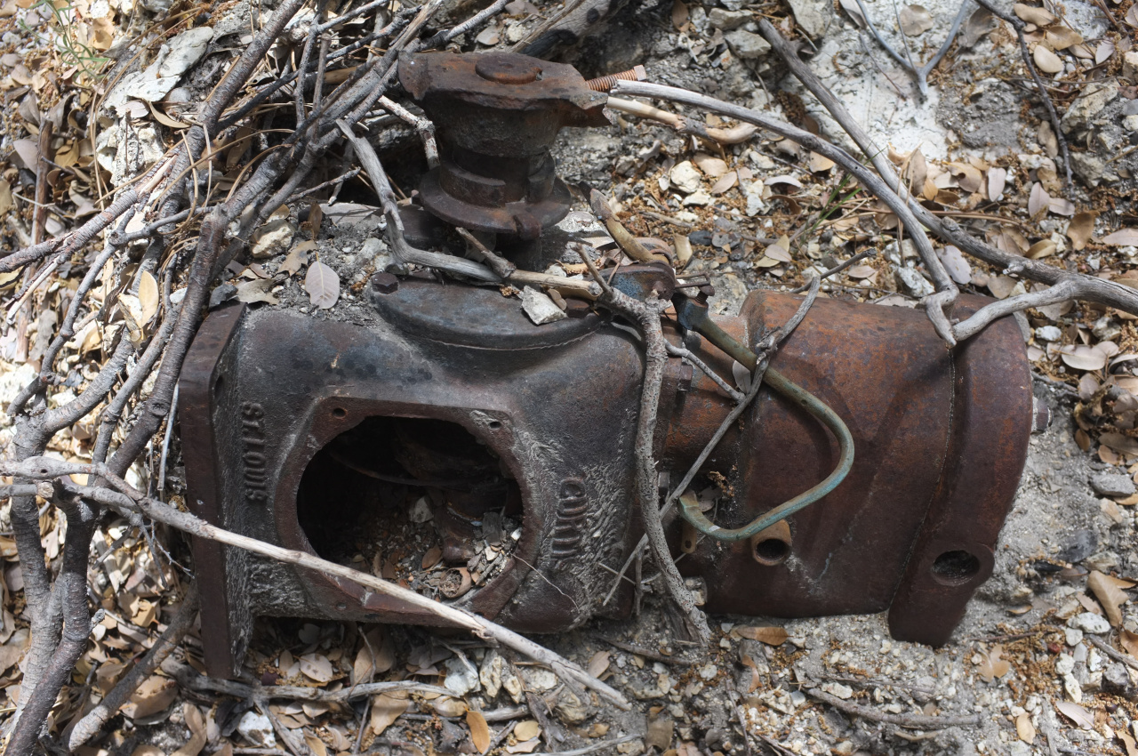
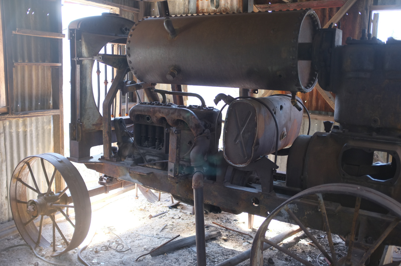
Also its odd that the compressor would have "1942" on the casting..that seems more like a year than a model number, but I could be wrong. But if the last test date with 1923 then maybe it is a model number, but I cant seem to find a 1942 model IR compressor.

I've signed up on vintagemachinery.orgs website and will try asking them to see if anyone can identify that machine. There is a huge following for vintage machinery like that online (just like everything else).

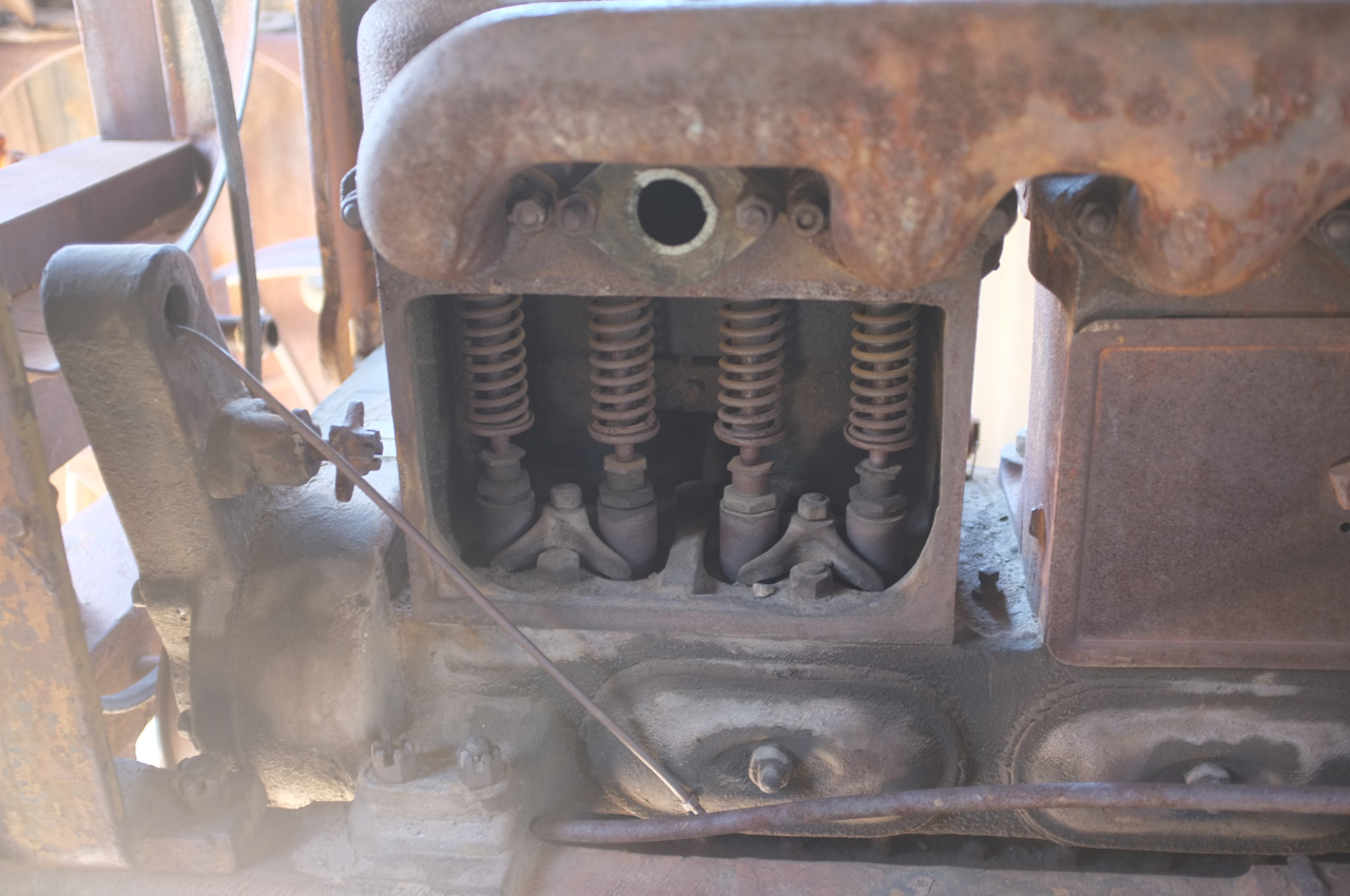
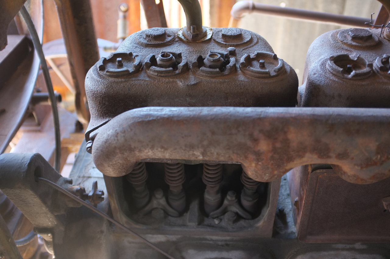
The machine may be not all "monolithic" so to speak...the compressor and engine or other parts may come from different manufacturers and have wildly different dates of origin.

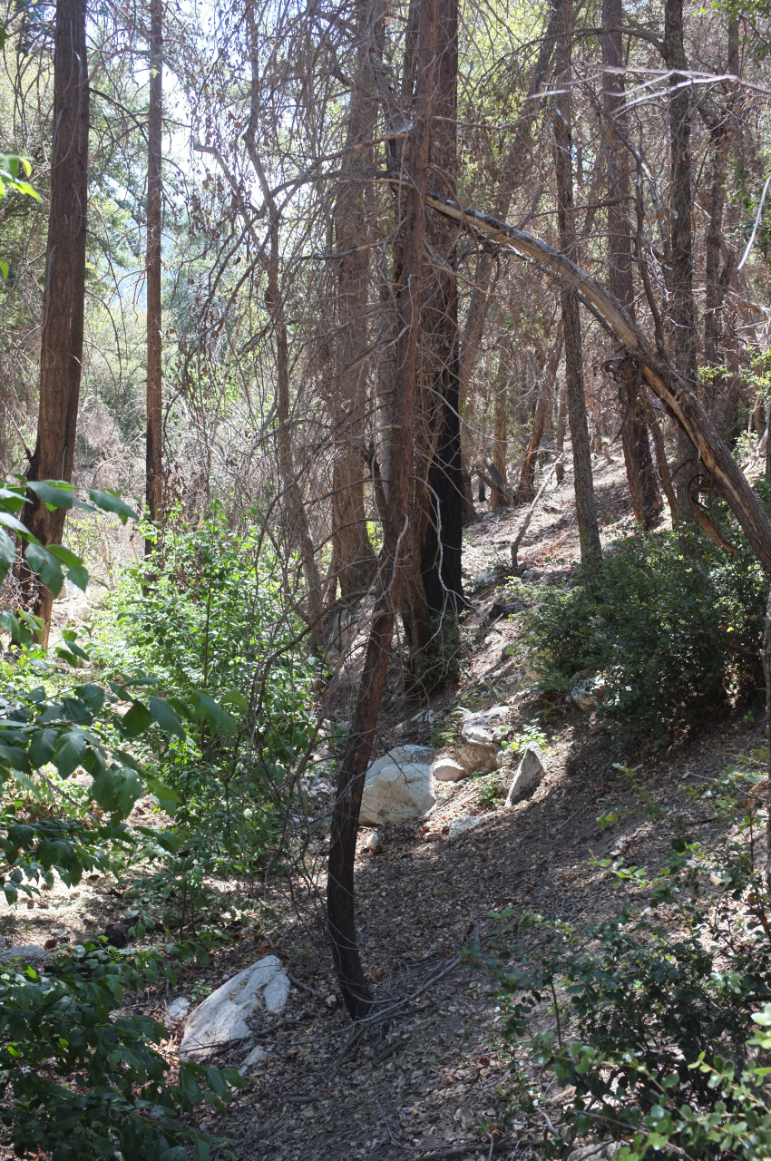
Also that other "machine" in the first couple pictures in this thread looks interesting, and it appears to have some info cast into it as well.

I believe this is the 1967 USGS report mentioned in that link you posted:

http://pubs.usgs.gov/bul/1230g/report.pdf

"Mineral Resources of the Devil Canyon-Bear Canyon Primitive Area, California By DWIGHT F. CROWDER"

I wonder if ol Dwight is still around?

Searching that report for "Boatwright":

"The U.S. Bureau of Mines made a thorough search of the records
of mining claims in the primitive area but found evidence of only
one recorded claim, known as the Boatwright. No records of any
mineral production were disclosed from the Boatwright prospect or
from any other areas within the entire primitive area. Paul V. Fillo,
mining engineer from the U.S. Bureau of Mines, accompanied the
author on a reexamination of the Boatwright prospect and on examinations
of other localities that showed some evidence of mineralization.
No mineral deposits of commercial grade were found."

But I thought on the USGS website it said "60 FT ADIT IN QTZ VEIN TRACE AMOUNTS OF MOLYBDENUM"...trace is not zero? Or I guess just not "commercial grade"?

Another part of the report:

"The only prospect found in the area was
examined in the company of Paul V. Fillo of the U.S. Bureau of
Mines; it is called the Boatwright prospect and is in sec. 26, T. 3 N.,
R. 11 W. It consists of a 60-foot adit driven along a quartz vein that
is 18 inches wide at its widest spot in the surface outcrop and less than
1 inch wide at the end of the adit. In the surface outcrop the vein occurs
as a short segment between two faults. Spectographic analysis
of the quartz reveals trace amounts of molybdenum and no detectable
gold."

"The only prospect found in the area was
examined in the company of Paul V. Fillo of the U.S. Bureau of
Mines; it is called the Boatwright prospect and is in sec. 26, T. 3 N.,
R. 11 W."

I wonder if that identifier is a map position or some kind of filing system report..are those mining reports public? Maybe a copy can be gotten from the USB of Mines? EDIT: probably not since the USBoM dissolved in 1996..but I would imagine the records are somewhere...


So how did it get the name Boatwright.......
User avatar
HikeUp
Posts: 3846
Joined: Thu Sep 27, 2007 9:21 pm

Post by HikeUp »

USGS Map Symbols.

***WARNING*** PDF file.

http://pubs.usgs.gov/gip/TopographicMap ... ymbols.pdf
User avatar
locator
Posts: 13
Joined: Tue Jul 28, 2015 10:34 am

Post by locator »

I think the NMMR took over for the USBoM and they probably have the records/maps..but they are down till mid August

https://en.wikipedia.org/wiki/National_ ... Repository
User avatar
locator
Posts: 13
Joined: Tue Jul 28, 2015 10:34 am

Post by locator »

so I guess its called a "prospect" when they are seeing what might be there, and a "mine" when they actually find something and start major excavating..

and Boatwright never made it to "mine" because there was just traces..and so they abandoned it.

Would be interesting to see who filed the claim and when....and of course the reason its called Boatwright
User avatar
missy
Posts: 83
Joined: Thu Jul 31, 2014 2:14 am

Post by missy »

locator wrote:
Very interesting!!!

Blanchard was just going by what John Robinson said in "Mines of the San Gabriels" right? I wonder what that book says specifically about the area and how Blanchard might have been misled?

"In John Robinson's Mines of the San Gabriels, published 34 years ago and long out of print, it is noted that two miners named Bell and Hartman did some small diggings around 1900 and later Charley Chantry (for whom the Chantry Flat is named) worked the area with little success."
I believe Blanchard may have been mistaken. He also said in his website that archaeologists are unaware of its existence. But mapping out the Angeles mines one day (based on the old mining data) I noticed that Boatwright was in the same location as the Bell-Hartman. Even the 60' adit fit the description. So it was definitely documented and known. Robinson was probably referring to a mine closer to the Chilao area.

http://caltopo.com/m/702F

Robinson was also kind of vague about where so Blanchard may have assumed that it was probably it. Boatwright sounds like a last name, but it could just be the name of the very late/recent mine owner.

As of the Ingersoll Rand compressor, 1942 could have been a model number but also if you look at this exact moment (13:55) there is another number you can see on the compressor:


I cant really make it out if it says 13328 22
But at the time I thought it said U328 22

Maybe that will help

Some similar compressors (maybe same ones)
Image

Image
User avatar
missy
Posts: 83
Joined: Thu Jul 31, 2014 2:14 am

Post by missy »

Heres a better resolution:


"That is a compressor to run a pneumatic jackhammer or rock drill. Waukesha gasoline 4cyl engine driving a two cylinder single stage air compressor (Ingersoll-Rand Type 20)."

Not sure if thats accurate, but thats all I have.
User avatar
locator
Posts: 13
Joined: Tue Jul 28, 2015 10:34 am

Post by locator »

missy wrote:
locator wrote:
Very interesting!!!

Blanchard was just going by what John Robinson said in "Mines of the San Gabriels" right? I wonder what that book says specifically about the area and how Blanchard might have been misled?

"In John Robinson's Mines of the San Gabriels, published 34 years ago and long out of print, it is noted that two miners named Bell and Hartman did some small diggings around 1900 and later Charley Chantry (for whom the Chantry Flat is named) worked the area with little success."
I believe Blanchard may have been mistaken. He also said in his website that archaeologists are unaware of its existence. But mapping out the Angeles mines one day (based on the old mining data) I noticed that Boatwright was in the same location as the Bell-Hartman. Even the 60' adit fit the description. So it was definitely documented and known. Robinson was probably referring to a mine closer to the Chilao area.

http://caltopo.com/m/702F

Robinson was also kind of vague about where so Blanchard may have assumed that it was probably it. Boatwright sounds like a last name, but it could just be the name of the very late/recent mine owner.

As of the Ingersoll Rand compressor, 1942 could have been a model number but also if you look at this exact moment (13:55) there is another number you can see on the compressor:


I cant really make it out if it says 13328 22
But at the time I thought it said U328 22

Maybe that will help

Some similar compressors (maybe same ones)
Image

Image
Those compressors are starting to look very similar.

I'll definitely post those numbers up on the vintagemachinery site along with the video.

This is a stretch, but I found a John Boatwright in a CA land claims/patents documents for the San Bernadino area..not quite right but pretty close.

http://files.usgwarchives.net/ca/rivers ... erside.txt

SB 0050S 0070E 008 532131 1916/06/06 BOATWRIGHT JOHN F

1916 seems a little too old..

I'm not sure what those coordinates are as far as a map. Maybe a connection can be made between this miner and the Boatwright miner somehow?

I spoke with Brianne Cassidy at the National Mine Map Repository and she said send her what info I had and she will see what info she has and get back to me in a couple days. They send out mine maps on jump drives. The oldest map they have is from the 18th century I think. I asked her if she knew who got all the "claims and patents" from the USBofM when it shut down and she said they did..but I dont really know what the document structure for mines are so I'm not sure if that means they have everything or if there are still other places with info..I would imagine California has its own document system with mines and what not. So I sent her the mine coordinates/names/USGS links..

I'm not sure how mine claims are filed but I would imagine they involve a map. So maybe if there is a map it will have a name(s) and other clues to this mines origins and dates.
User avatar
locator
Posts: 13
Joined: Tue Jul 28, 2015 10:34 am

Post by locator »

from that CA claim/patent doc:

"Using this information you can obtain copies of the patent file for $10 from
the National Archives at the following address:

Reference Branch (Lands)
National Archives
Washington, DC 20408
(202) 501-5428 "


wow ...that could be useful in the future

or if we can figure out what those coordinates are as far as a map, and then look backwards from where the Boatwright prospect is and find it via its coordinates in that list, and then the patent/claim for it muhahhahaa
User avatar
locator
Posts: 13
Joined: Tue Jul 28, 2015 10:34 am

Post by locator »

okay that township coordinates system is some kind of government blm/gis thing

looking at this map it looks like the same coordinate system is being used

so my idea is, if you know where a mine/propsect is, and want to find the patent, locate it using GPS or whatever on the PLSS system, then you can see its township coordinate system location, then use that to look it up in that huge text file of california claims/patents which will give you a name and maybe even a copy of the patent/claim

http://www.geocommunicator.gov/blmMap/MapLSIS.jsp

I'm not completely sure how the PLSS coordinates work..but it looks like the boatwright prospect is in, from least to most precise:

Los Angeles County alternate source dataset (not blm?)
3N 11W (township...because its a 36 sq mile area)
26
NESW


[/IMG]
User avatar
locator
Posts: 13
Joined: Tue Jul 28, 2015 10:34 am

Post by locator »

okay so the township range section works like this:

http://nationalmap.gov/small_scale/a_plss.html

I downloaded the township grid for CA here, which is viewable in google earth.

http://www.earthpoint.us/TownshipsCalifornia.aspx

Then I imported the CA land patents database text file into excel and sorted by township and range.

Unfortunately none show up in section 26, which is where the Boatwright prospect is. The closest is probably section 24, from 1907, a "NEWCOMB LEWIS G". That section is about 1 mile from the center of section 26.

But who know how accurate these maps were when the claims were made?

This process seems like it could come in handy for identifying patents/names/dates for mines.

Maybe I just did this wrong somehow. Someone check my work!

Heres the short list:

Image
User avatar
locator
Posts: 13
Joined: Tue Jul 28, 2015 10:34 am

Post by locator »

this database also seems to have a search function for land patents nationwide...

http://www.glorecords.blm.gov/results/d ... sadv=false

some of them have images, I just looked at the lester loomis 1919 patent in pdf format free!

but the CA textfiles have some entires that are not showing up in that database..interesting

but the glo records website seems to have more info on each patent..there are tabs with other details
User avatar
locator
Posts: 13
Joined: Tue Jul 28, 2015 10:34 am

Post by locator »

as far as Dwight Crowder, the geologist/author of that USGS report that names "Boatwright Canyon"..I am pretty sure hes dead. Him and his wife died in separate car accidents (30 years apart) on the same road very near each other.

"Environmental leader Betsy Crowder killed in accident "

http://www.almanacnews.com/morgue/2000/ ... wder1.html

"Both Dwight and Betsy were involved in the founding of the town of Portola Valley," Mr. Brown continued. "She has been involved in every conservation struggle, movement, battle, for the last 40 years."

Mt Crowder is named after Dwight.

Looks like Dwight was killed on that road in 1970..3 years after that report was written.

But what about Paul V. Fillo....?
User avatar
locator
Posts: 13
Joined: Tue Jul 28, 2015 10:34 am

Post by locator »

got a response from NMMR (national mine map repository)

Despite the accurate information you provided, we were unable to locate any further documentation in regards to the "Boatwright Prospect" (as well as "Bell Hartman"). However, there is one mine in our database that involves Molybdenum as a mineral resource, but is quite far from your given coordinates (Pine Creek Mine - 37°21'42.0"N 118°42'12.0"W) . Let our office know if we can fulfill any future inquiries you may have. Thank you and good luck in your search.
User avatar
Joe_the_Hiker
Posts: 10
Joined: Mon Mar 30, 2015 8:50 pm

Post by Joe_the_Hiker »

This mine has been kept a secret for almost 100 years... can we keep it that way? Please delete your post with the location. I deleted my previous posts on this thread also.
Post Reply