As posted with the OCHC, let me know if you want to go. Firm commitments only, please.
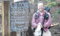
At 11,499 feet, Mt San Gorgonio is the tallest mountain in Southern California. The summit can be reached via a challenging day hike or a leisurely three day backpacking trip. But this time we will tackle the summit in a single overnight, spending the night at the top.
This is a long overnight backpack climb that should be attempted only by experienced backpackers in excellent physical condition.
Type of hike: Overnight summit backpacking lollipop
Hike distance: 24.7 miles round trip.
Elevation gain: 4,619 feet
Estimated time: Two days
Note: The Wilderness Permit only allows groups of up 12 people, so that is a hard ceiling on the number of folks who can RSVP. If your plans change, please remember to change your RSVP to ensure that someone else can come along on this hike.
ROUTE
Day 1: (11.6 miles; 4,619' elevation gain)
We will begin the hike at the paved trailhead parking area for the South Fork Trail (6,880 feet). The trail climbs 2.4 miles up to Poopout Hill, where we will enjoy a glorious picture window view of our destination for the day, Mt San Gorgonio. Then after a gentle 1.8 mile hike to South Fork Meadows, we will stop for lunch and also to fill our camp bladders with water. This will be the last water we will see until the next day.
After South Fork Meadows, the real climbing begins, up around Dollar Lake to Dollar Lake Saddle (10,000 feet, 7.5 miles into the hike). After Dollar Lake Saddle, we will traverse along the south side of the ridge leading up to the summit for about four miles, finally arriving at the top late in the afternoon.
Again, since there's no water at the summit where we will be spending the night, we will have to stock up at South Fork Meadows, and carry at least a gallon per person the last 7.4 miles or so to the top. This means you must bring extra water bottles or camp bladders.
We will camp, like troglodytes, in stone pits established at the top as protection from the howling summit winds.
Day 2: (13.1 miles; 4,619' elevation loss)
After a beautiful night under the stars, we'll break camp and head back down the Sky High Trail around the south and east sides of the mountain, to Mineshaft Saddle. From there we will proceed down through Trail Flat to Dry Lake, and then to South Fork Meadows. From there we will retrace our steps back to the trailhead parking lot.
MAPS AND LINKS
I will upload a map shortly. Here's a link to some pics from a similar hike we did in August.
GETTING THERE
We will meet in the parking lot of the South Fork Trailhead, on Jenks Lake Road, 2.5 miles from Highway 38, at 7:00 sharp (check out this map). Please plan to arrive 15 to 30 minutes early. Carpooling from Orange County is encouraged. To ensure an early start, you might consider spending Friday night at the Whispering Pines Cabins in Angelus Oaks (909-794-9644).
CARPOOLS
Carpooling from Orange County is encouraged and hike participants should arrange them amongst themselves. An Adventure Pass is required for any car parked at the trailhead.
WHAT TO BRING AND HOW TO PREPARE
This hike is for experienced backpackers who already know what to bring on an overnight trip. Be sure to carry at least two liters of water with you for the ascent to South Fork Meadows, where we will get at least a gallon more per hiker (filter before drinking). This means you need to pack extra water bottles or camp bladders.
Please be sure to bring personal sanitation equipment (toilet paper and a trowel) as well as a bear-proof food container. Bears are particularly active in the Vivian Creek drainage and for all I know may enjoy moonlit raids on summit campers.
Always be aware of anticipated weather conditions. Check this site before the trip for up-to-date forecasts.
In any event, it will be cold on the summit Saturday night, and probably windy. A tent is less effective in the wind than a bivy sack. Any forecast of rain or other inclement weather will cancel the hike.
Sleep on the Summit of Mt San Gorgonio Halloween Lollipop
Nunc est bibendum
Those of you who told me they are coming along be sure to meet us at the trailhead at 7:00am tomorrow.
You know who you are.
You know who you are.
Nunc est bibendum