

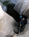
I played hookey yesterday and joined a few others to do this canyon. We had been informed by a group that was there just a week before that there was only one waist deep pool among the 8 drops but it turned out to be a lot wetter than we expected. There were several pools at least that deep depending on your precise landing spot. Navigation to the drop in point can be an issue as I had sensed from reading Brennan's directions. We took a new route that turned out to be steeper than hell - that was an adventure in itself as we had some close calls with falling rock. But I think we cut off some time even from the shortcut that Brennan mentions.
Anyway, this canyon deserves its reputation as some of the best canyoneering in the San Gabriels.
Great Falls of the Fox
While an approach to the GFF is never as simple as leaving a trail and being in the canyon right away, creating new trails just because someone cant navigate is a hypocrisy. I cant think of anything more destuctive to an environment than that. Part of the GFF route in my opinion is its committing approach. Or maybe it needs this 6th approach. 
As far as being quicker, I would have a hard time believing that.
Just my 2 cents.....
As far as being quicker, I would have a hard time believing that.
Just my 2 cents.....
Now, calm down. Your 2 cents come with some heavy accusations. First, when I said navigation is an issue, I meant that you certainly need to pay attention to the route to get to the drop in point for GFF, not that I built a new trail because I can't navigate. Second, neither I, nor anyone with me, "created" a new trail. The partial trace trail/path we used for our drop into the gorge was already there. And I think your logic is twisted somewhat: whoever did build that use trail needed good navigation skills to get toward the destination.AW wrote:While an approach to the GFF is never as simple as leaving a trail and being in the canyon right away, creating new trails just because someone cant navigate is a hypocrisy. I cant think of anything more destuctive to an environment than that. Part of the GFF route in my opinion is its committing approach. Or maybe it needs this 6th approach.
As far as being quicker, I would have a hard time believing that.
Just my 2 cents.....
Finally, how pure an environmentalist do you want to be? Isn't the bolting of rocks, tieing webbing around trees graced with rapides, and trampling brush as you descend the canyon, destructive of the environment?
My response is not meant to be combative, but your shoot-from-the-hip approach to delivering your 2 cents required setting the record straight.
Augie,
Didnt mean to say you were out blazing new trails. I know the trail was built the days before you went. As far bolts&webbing are concerned, I feel are necessary to descend a canyon. I think bolts can be limited by the education of how to use natural anchors and also the education of how to install bolts for canyoneering purposes.
Navigation is not taught past overview level by most techincal outlets. I can understand the focusing on the technicals that can prevent death from using a rope. And people find their way to canyons w/ GPS if needbe, therefore there isnt a whole lot of demand for navigation, especially for sport 'canyoneers'. The benefit of navigation is access ,and the root of that is environmental awareness.
At the end though its a simple disagreement and I dont mean to make it into something greater as I think the chances of navigation education taking off is rather dismal.
AW,
It doesn't sound like we have much disagreement after all. No question you have to leave webbing and rap rings even with natural anchors (putting aside the rare situation where you might sling your rope directly around the anchor and hope that you that you can pull it down afterward). And I agree that people are not likely to seek out extensive training in map and compass use unless they have a specific reason and the inclination do so. It's probably not a good trend that people rely on GPS primarily and possibly exclusively without learning the fundamentals of map and compass.
Cheers,
Augie
I don't if the people frequenting this board need it, but the Sierra Club has an excellent course, Wilderness Travel Course (WTC), that has an excellent segment on land navigation.
I grew up with topo maps since my dad was an avid hiker. I was a Boy Scout and an Army Officer, and I am a Sierra Club leader. I thought I knew map and compass pretty well, particularly since I had been through the US Army's extensive training and had even been a land nav instructor, but I found that WTC actually gave me some helpful, practical tips which have subsequently served me well.
The course is taught in the San Gabriel Valley, West LA, Long Beach, and (I think) Orange County. It's a pretty big time commitment, but I found it really worthwhile and a lot of fun. http://angeles.sierraclub.org/wtc/
Jim,Hikin_Jim wrote:I don't if the people frequenting this board need it, but the Sierra Club has an excellent course, Wilderness Travel Course (WTC), that has an excellent segment on land navigation.
I took WTC several years ago. I agree that the course provides great instruction in map and compass use; navigation is perhaps the topic most focused on in the 10-week WTC course.
Canyoneering navigation is a different bird, considering the use of ropes&clothes among others. Basically its how to approach a canyon, how to deal w/ obstacles, and how to deal w/ defeat until the canyon is breached.
All aproaches deal with waterways. Waterways being defined as any waterway, as a person only needs enough room as they are confined to, not a wide trail. In 2 of the approaches, via Fox Pk & via Fox SE ridge thats what those are, there is no trail as hikers understand it. But this is key to canyoneers as with the right understanding, canyoneers can go descend into canyons they havent even seen in person.
The 'difficult cross-country' approach is for those who have to have bigger pathways, so you get a discernable trail, a few ribbons here and there to know you are at a key location, and dont have to worry about breaking out a rope. With this understanding, a lot of beta routes fall into place.
Blazed trail approach is for those who will need a trail sign/GPS.
Perhaps WTC course covers the last 2 is what Im thinking.
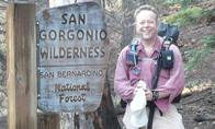
I did a trip report for SummitPost on my Nov. 19 Great Falls of the Fox outing along with some photos. Here is the link. http://www.summitpost.org/trip-report/3 ... e-Fox.html.

The granite is probably the best I've seen in the San Gabriels.TacoDelRio wrote:Fantastic pics, Augie! The granite there looks out of this range!