After hiking David R’s two fire break routes down from Magic Mountain Summit and up to High Point, Kurt and I were ready for more. We’ve been working our way east through the MM Wilderness area and though there are lots of intriguing old fire roads and long wide fire breaks, many of them can’t be accessed from public roads because of private land holdings between Soledad Canyon Rd., Aliso Canyon Rd., and Angeles Forest. I've spent a lot of time driving around and scouting, looking for access points and trying to cook up shuttle vehicle and loop hikes that avoid backtracking. I came up with a few routes, and we hiked the first one yesterday.
South of Soledad Canyon Rd., between 4N37 (“Backcountry Discovery Trail”, actually a fire road) and the PCT I noticed another long fire break that runs up to Santa Clara Divide Rd. It doesn't appear on the Harrison or USGS maps but is shown on AllTrails, and is clearly seen in satellite views. That seemed like a good prospect so I planned a semi-loop hike, climbing up the firebreak to the divide, then returning on the PCT. We were ready for a good long hike with a variety of views and trail conditions, and got just that.
Unlike my wife, other friends, and most sane people, Kurt and I love to start these hikes VERY early. We met on Saturday at 3:45 (our usual time) and headed out. A lot of rain had fallen in L.A. Friday evening and touching base that night, we wondered if we might be slogging through mud and fighting slippery hillsides. But, exiting the 14 and driving east on Soledad Canyon, there were no puddles on the road and soil near the shoulders looked quite dry.
We parked at the trailhead, which has a large lot and rest rooms. From there you can take either 4N37 or the PCT, which intersect two more times on the climb before diverging. We took the fire road to shave off a half mile or so, then turned left on PCT and headed southeast. The trail was almost completely dry. It was about 5 AM, with no moon, but from star light we could just see that the upper half of the range was dusted with snow. It was about 34 degrees.
About 2.9 miles up we hit the start of the fire break. The PCT doesn’t quite intersect with it, but a very short scramble gets you up to the ridge where it starts. I cached a liter of water for the way back and we headed up. After our previous fire break hikes the drill was familiar — steep climb up, reach a hilltop, descend and then start climbing a bigger hill, rinse and repeat. The soil was still very dry. As before, I was really glad to have hiking poles.
About a third of the way up we began to see the remains of an armored multipair telephone cable, which follows the ridgeline up. It amused Kurt, who worked in cable and electronic parts sales for decades and me too, an electronics nerd and former “phone phreak.” Part way up it’s spliced to a smaller single pair cable, which continues up the break. Like the other firebreak routes, little navigation is needed here — you just keep to the ridge and take the steepest way up, with the telephone cable always in front of you.
About halfway up we began to hit snow, which added an element of fun to the climb and made walking a little easier. By the time we reached the divide it was about 6 inches deep. (Not as deep as the snow we’d stomped through coming down from the installation at MM summit after the last snowfall up there.) The weather forecast had predicted cloudy skies, but it was crystal clear, with fantastic views in every direction. Mendenhall Ridge had some snow, but not nearly as much as we saw on the 2nd.
The last climb up to the divide is long, steep, and very brushy in places. At times it was easier to skirt the left or right flank for a while, and then return to the telephone cable. Finally we hit the Santa Clara Divide Road and turned left, reaching North Fork 2.5 miles later. The resident ranger came out to say hello, mentioning that he too was surprised by how little snow and rain had fallen near there compared to other places around L.A.
PCT crosses the divide at North Fork. This is a beautiful hiking area, and the fresh snow made it even better. I’ve hiked very little of the PCT, but can’t get over how it’s so beautifully graded and groomed — almost as if crews go out there with shears, a broom, and a dustpan every week. Of course all those level grades often mean more distance, and the way back involved a lot of zig-zagging, but it was excellent walking.
Descending from North Fork I pondered the Moody Truck Trail off to my right, a long, prominent diagonal fire road that begins at Aliso Canyon and ends at North Fork. I saw another interesting looking fire break that appears to follow a nearby ridgeline and then intersect with Moody. Maybe the combination could be another good loop through the area, but private parcels and lack of access might make that one more trouble than it’s worth. (More research needed.) I think our next route will be a 4N24 / PCT shuttle car hike, east of Mt. Gleason — maybe next weekend. I’ll post the trip report here if it works out.
The final toll: 15.5 miles, 3109’ of climb, 2 very sore knees (mine) from the descent. Just 2 or 3 stalks of old, dead poodle dog bush. We usually make good time, but this one was slow. It took 11 hours, with lots of stops for snacks, photos, rest, and clothing changes. Besides the ranger at North Fork we saw two solo hikers on the PCT. https://www.strava.com/activities/4677031902
Indian Canyon / North Fork Loop, via Fire Break and PCT
-
David Martin

- Posts: 85
- Joined: Sun Nov 08, 2020 7:08 pm
-
- Heading back to the trailhead, with Vasquez Rocks in the distance (left side)
-
- Starting down the PCT from North Fork
-
- Santa Clara Divide, looking east
-
- Looking back down the fire break, with the ever present telephone cable
-
- The biggest and steepest part of the climb
-
- View to the north
-
- The roller coaster climb ahead
-
- South view from a hilltop
-
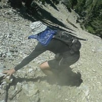
- Let's see. Blue/white is pair 1, orange/white is 2, green/white is 3...
-
- Looking south down the fire break at dawn

Thanks for the report. I've also been focused on that area of the Gabes, so I'm interested in different routes over there. Some time ago I considered those ridges around the Moody Road when I was researching ways to Gleason. They might be good for shortcuts, shaving off mileage along the meandering road. I drove 4N32 from Aliso Canyon west past the quarry to the gate at Moody Road. You could park there.
-
David Martin
- Posts: 85
- Joined: Sun Nov 08, 2020 7:08 pm
Dima, good question about the fire. I wasn't paying close attention, but we did see fire evidence while going up the break. In that photo of the telephone cable you can see that the ground is sort of blackened and ashy. A lot of the larger / older vegetation looked burned, and the cable itself was burned in places. But the area of the PCT, about a mile east, seemed healthier. I don't know what direction the Sand fire traveled and what other fires have affected the area but maybe that firebreak did its job and mitigated damage to the east.
Sean, you’re welcome. The lack of a good vehicle approach to Moody Road and the Santa Clara Divide has stifled some routes around there but I’ve found a few work-arounds. In December I canvassed around, looking for access to Moody, but mostly saw No Trespassing signs, fences and locked gates. One opening might be "Thousand Trails”, a private camping / RV resort. We took a little stroll around there one day and though there were people around, no one took much notice of us. Maybe one could walk through there to the power line road, and on to Moody, but the first mile would be private property, and I think you’d have to pass a ranch at the boundary of Angeles Forest.
I think the center portion of Santa Clara Divide Road was open to private vehicles but it’s now gated at the Sand Canyon junction, and when we walked that section a few weeks ago we could see why. Less than a hundred feet east of the gate there’s a section of hillside that has slipped away, leaving just air beneath half of the pavement. I saw a maintenance vehicle on it once, probably associated with the installation on the summit, but that section’s sketchy and will be difficult to repair.
Thanks to satellite views I have my eye on another fire break route; from Mt. Emma Rd., over the top of Mt. Emma, south to the PCT and hang a right, then finish at Mill Creek Summit. That one just might work.
That whole area has made for some great winter hiking. Walking there would probably suck in the summertime, but in this season it’s just right. The winter weather and fire damage haven’t been show stoppers. The firebreaks are mostly steep and sometimes ugly, but offer amazing views. I miss seeing trees but the we hardly ever see other people. As you all know, it’s fun to research these weird little routes, then successfully walk them. And there’s almost no litter. (If I see any, I carry it out now. Otherwise I’d feel guilty for two days, thanks to Dima’s influence ?)

Be aware that you'll pass near Desert Marksmen Shooting range on your way from Emma To Cole. A bit disconcerting.David Martin wrote: ↑... from Mt. Emma Rd., over the top of Mt. Emma and then south to the PCT and ending at Mill Creek Summit. That one just might work out.