
Started out at the WestForkSGRiver parking early...5:15am. The moon was out and showed the way. Sort of eerie, with visibility limited to just the path with the shadows of tall trees and owls hooting nearby. No sunrise, but a slow transition from black&white to color, just in time for the excellent view of Twin Peaks west ridge.
A walk across Cogswell dam, and the sound of a security camera from behind. Then the sound of a truck pretty quickly thereafter, and I explained that I was just hiking to Devils canyon. I mentioned that perhaps I should change my plans to instead hike up the ridge. Employee told me that an old-timer had one time done just that some years back. Went 1/5 of the way there and came back with his army jacket in shreds, telling of rugged terrain with cliffs. OK, the words were the most rugged terrain in the San Gabriels, which brought a smirk to my face....a challenge..hmm..
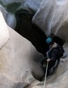
Ventured off into Devils canyon, which the only way I could describe it was much like the east fork of the SG river. The well used trail for the most part kept the creek out of view. Occasionally there was a pond or two. I was sort of thinking it would be more scenic , and then the trail ended into a bushwack. I didnt know I was very close to side falls as described by Brennan, and turned around, exiting the canyon at 11:30am.
All the way back to the parking lot getting there at 2:30pm including a visit to my favorite pool. Ending of the trail was marred by fresh graffiti.
Then I drove up to the Valley of the Moon. A short hike to a ridge which I could see the creek and Lost canyon...neat view.
Baldy had very little snow from the Highway39 view...water levels were quite low.
Lower Devils canyon-Wed 12/26


>Did you take a bike from West Fork to Cogswell Dam?
Nope....in actuality I planned to stay overnight at Glenn trail camp and do another hike from there the next day(that Twin Peaks ridge).....but instead of carrying a bunch of stuff in, I brought along a small luggage carrier...lots of luck, at the pace and noise I was making, I would have to had cancel one of the routes anyway...hehehe...I luckily made the decision early enough to stow it back away. I dont think I was ready to leave my car overnight as well, so it all worked out. Got a few of the pictures I had been missing.Using a bike is optimal indeed...that would cut down the mileage by over 14 miles.
Speaking of Cogswell dam, that had to be some low low water levels. The way things are going and I wonder how they will have enough water to release later this summer.
Heres the only picture I took of the ridge...