Peak 4,054

TRs for the San Gabriel Mountains.
Post Reply
User avatar
David R
Posts: 527
Joined: Sun Jun 12, 2011 10:28 pm

Post by David R »

For some reason I continue to hike the Magic Mountain Wilderness, there are few redeeming qualities other than there are no official trails through the area. When I first looked at the area the peak that initially interested me was Peak 4,054 which is smack in the middle if it. Despite this I have hiked through it to all the other peaks in the area. I decided this Sunday to give a stab at 4,054, even though I knew that most of the brush had grown back which had allowed my initial access to the area. The secret weapon to entry into the area is the fact that the Acton Conservation Camp is located right off Soledad Canyon. The inmates spend much of their time supporting the fire department in fighting fires. While they are at the camp they have been very busy creating fire breaks along the ridges surrounding the camp. When I had hiked Magic Mountain High Point, this had allowed me to get 2/3 of the way there. That ridge dropped to a low point where you could cross the canyon and go up a steep ridge to the top of 4,054. I had looked at that ridge on my way back from the MM High Point but was tired and running out of time so opted to leave it for another date.

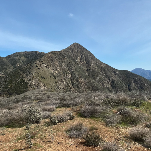
Since all of the trails start from the camp which is off-limits, you need to find another access point to get to them. There is a small canyon just to the west of the camp. Most of the canyon is fortunately brush free on the bottom. You have a small dry cascade to clamber up at the start. You can then either take the first draw you hit on the left or the preferable route is the second one which is a little less of a clamber and an easier use trail to exit on to the ridge. From here you are on a massive fire break. I was surprised to see that the fire break system in the area has been significantly increased. Of the most interest was I noticed that only a little further up this westerly canyon a fire break had been cut to the bottom and up the N/S ridge that led to 4,054. It looked very steep but also looked like it would get me very close if not all the way to the summit.

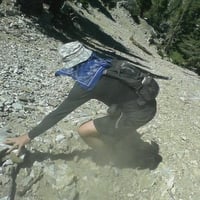
I altered my plan and decided to cross over and follow the fire break to the other side of the canyon. The constructors have named their trails, the one that cuts off to the right that takes you down into the canyon is called Cyclone and the one that climbs up the ridge is called No Fear and the final route along the western ridge is called Lay In. Cyclone drops you down to the creek which was still flowing which was nice to see but lots of bugs were enjoying the water as well. No Fear is really steep with lots of loose dirt and rock. The incline does not minimize much once you're on Lay In and I could see clearly that the fire break should take me to the top. There was still lots of flowering plants with tons of bees but they didn't bother me much. I did not realize how warm it was going to get and with no shade the final climb in the mid-80s was kinda unpleasant and I was tired. Finally I made it to the top and it was a commanding view of the area even though the south ridge was higher. There was a cairn there and they had cleared out a section of the top. With the heat and the bugs I didn't spend much time on the top and started the steep descent pretty soon after getting up there. The final climb out of the canyon while short was really unpleasant with the heat but before I knew it, I was back to the car, happy to have wrapped up the peaks in the area. The hiking time was 3:45 for about 5 miles with about 2,500 feet elevation gain.

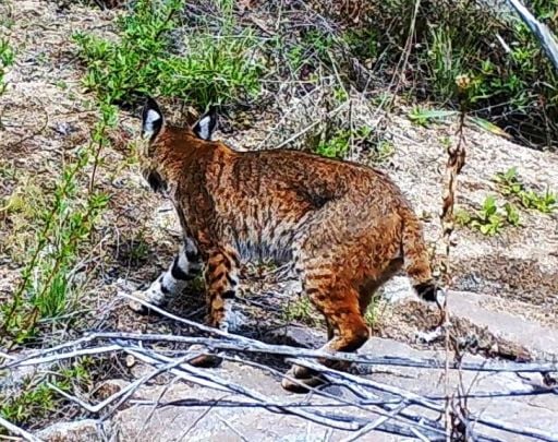
Some pics from the top.
thumbnail_IMG_2698.jpg
thumbnail_IMG_2699.jpg
thumbnail_IMG_2700.jpg
User avatar
HikeUp
Posts: 3846
Joined: Thu Sep 27, 2007 9:21 pm

Post by HikeUp »

nice
User avatar
Nate U
Posts: 228
Joined: Wed Apr 05, 2023 7:38 pm

Post by Nate U »

Thats an obscure one, I salute you. I haven't accessed Magic Mountain Wilderness from the north/Soledad Canyon yet. That whole area is within the realm of the Sand Fire. Not summer-friendly!

Do you have a cumulative map of some kind of your adventures?
User avatar
David R
Posts: 527
Joined: Sun Jun 12, 2011 10:28 pm

Post by David R »

Nope I keep most things in my head and there is so much change especially with the frequent fires that it feels like the wilderness is getting recreated every 10 years or so. Some of my favorite early hikes have been changed forever.
User avatar
Sean
Posts: 3748
Joined: Wed Jul 27, 2011 12:32 pm

Post by Sean »

Thanks for the report. Do you mean there is signage with the names for the firebreaks?
User avatar
tekewin
Posts: 1194
Joined: Thu Apr 11, 2013 5:07 pm

Post by tekewin »

Thanks for the report and the beta on access. I have a vague idea where this peak is based on your photos. Pretty cool hike, but I agree with your assessment that the area is not really attractive.
Post Reply