Smith and 5490

TRs for the San Gabriel Mountains.
Post Reply
User avatar
JeffH
Posts: 1154
Joined: Sun Nov 28, 2010 7:09 am

Post by JeffH »

After reading all of Taco's reports this week I'm almost embarrassed to say I drove to this trailhead...
It's been a couple of years since I visited Smith Mountain, and on my previous trek I thought I could head up the peak just not of the saddle and then walk down the firebreak and rejoin the trail. So last weekend I left the house relatively early, I was the first car to park at the Bear Creek trailhead. Not much to talk about as this is a well-known track, there was a little bit of water running at the last of the canyon crossings. The north side of Smith had a bit of snow, it was a little soft. I didn't think it was enough to be dangerous but enough to be careful. Sometime in the recent past folks have tied pink ribbons on the way up to guide the way. I went past a few of them and went alternate routes around others. A nice break at the summit was followed by four people arriving to join me so I promptly went down. From the saddle I went up the firebreak, which is pretty steep. It seems to get softer and more gravel-like on the ascent which of course made the walk harder. I took a longer break at the top of Peak 5490, views were fantastic out toward Catalina and over the Station Fire burned areas. Walking down from there, I took a while to actually find the firebreak going down the east side, it's much clearer in the satellite photo than in person. It's also very soft and chewed up, I was expecting a nice smooth road so once I started down I wasn't about to go back up. I'm curious about the process to make these breaks, this one is full of bumps and depressions mixed with chewed-up brush. The dead brush is so dry I think the fire hazard is higher now than when this work was done. Anyway, it was a long slow journey downhill, I fell twice from my feet getting caught up on some branches. As I neared the trail, I had to go straight down the side of the mountain for about 50 vertical feet. I somehow took the same path that another human had followed recently, as I saw the same footprints and trekking pole scars that I was leaving. Once back on the trail it was just about a mile further in the warm sunshine back to my vehicle. I also learned the McDonalds on Azusa below the 210 is definitely the cleanest one around.
AllTrails claims about 7.5 miles and 3100 feet of gain/loss.

Starting out on the trail, Smith in view.
IMG_9960.jpg


Smith from the saddle - light snow coverage.
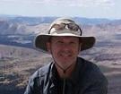
IMG_9975.jpg


Smith summit.
IMG_0005.jpg


Eyeing the firebreak route up 5490.
IMG_9980.jpg


View of Baldy from most of the way up the firebreak.
IMG_0023.jpg


Summit of 5490, so much for my dream of a first ascent.
IMG_0026.jpg


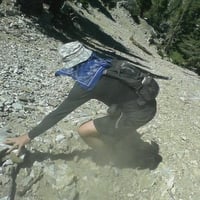
Looking for the firebreak, it was downhill further than I thought.
IMG_0054.jpg


The route down.
IMG_0055.jpg


In the midst of the crummy terrain I found a couple of pine trees that looked to be intentionally planted.
IMG_0057.jpg


The firebreak ran out near this ridge, I had to get to the far side to rejoin the trail. Pushing through a lot of bushes here.
IMG_0068.jpg
"Argue for your limitations and sure enough they're yours".
Donald Shimoda
User avatar
dima
Posts: 1319
Joined: Wed Feb 12, 2014 1:35 am

Post by dima »

Cool stuff! I've looked at those firebreaks many times, wondering. Glad somebody did it!
User avatar
HikeUp
Posts: 3846
Joined: Thu Sep 27, 2007 9:21 pm

Post by HikeUp »

Nice hike! Cool pics. Thanks.

I've had the luck of watching (through binoculars) the bulldozers making firebreaks on unbelievably steep ridges (in the Verdugo's). They defy gravity while destroying everything in their path, then backing up over it and destroying it again. Looked to me that they were just basically trying to till the vegetation into the soil.

This was a couple of months after the Station fire on high point 4320+ near Henninger. The fire never got here but this was part of a break they made between Muir Pk. and Hastings Peak (it ran down to near Idlehour, then up to 4320+ then over to Hastings. All I could think of was how destructive the dozers were to till the soil of all the rocks and brush into this trail of derbis.

IMG_5538.jpg
User avatar
Sean
Posts: 3748
Joined: Wed Jul 27, 2011 12:32 pm

Post by Sean »

Thanks for the report. That's a cool route I'll have to keep in mind. Never been up to 5490. Is that the one you can also reach from the top of CA-39?

You timed that jump perfectly.
User avatar
Girl Hiker
Posts: 1318
Joined: Fri Apr 04, 2014 7:46 am

Post by Girl Hiker »

Whoooohooo!!!
Love that jump
User avatar
JeffH
Posts: 1154
Joined: Sun Nov 28, 2010 7:09 am

Post by JeffH »

Sean wrote: Thanks for the report. That's a cool route I'll have to keep in mind. Never been up to 5490. Is that the one you can also reach from the top of CA-39?

You timed that jump perfectly.
Yes, the dirt road goes from what looks like the part of 39 after the turnoff to Crystal Lake. That would certainly be an easier route but where's the adventure? Hmm, maybe a loop with two cars would be good. Mix with an overnight on 5490 summit.
"Argue for your limitations and sure enough they're yours".
Donald Shimoda
User avatar
Taco
Posts: 6001
Joined: Thu Sep 27, 2007 4:35 pm

Post by Taco »

Heheheheheheheheeehhhh

I thought it was 5495! Harrumph. I ran down from the summit to the saddle with Smith once and got a big Yucca needle into my ankle.
User avatar
JeffH
Posts: 1154
Joined: Sun Nov 28, 2010 7:09 am

Post by JeffH »

My phone also got it at 5490.

Image
"Argue for your limitations and sure enough they're yours".
Donald Shimoda
User avatar
HikeUp
Posts: 3846
Joined: Thu Sep 27, 2007 9:21 pm

Post by HikeUp »

Taco is 5ft tall?
User avatar
Taco
Posts: 6001
Joined: Thu Sep 27, 2007 4:35 pm

Post by Taco »

I wear a sensor atop my head. I just looked at Acme Mapper with 'USA Topo' setting and it says 5495 on it.
User avatar
HikeUp
Posts: 3846
Joined: Thu Sep 27, 2007 9:21 pm

Post by HikeUp »

Actually there is a higher pt just yards to the north of the 5495 location that is 5520+. And just yards to the south is slightly higher too.
Picture1.png
User avatar
Sean
Posts: 3748
Joined: Wed Jul 27, 2011 12:32 pm

Post by Sean »

Peakbagger has it wrong too. I blame the internet.
User avatar
Taco
Posts: 6001
Joined: Thu Sep 27, 2007 4:35 pm

Post by Taco »

I live in a world of absolute chaos where numbers mean very little.
User avatar
Sean
Posts: 3748
Joined: Wed Jul 27, 2011 12:32 pm

Post by Sean »

JeffH wrote: My phone also got it at 5490.

Image
Unfortunately those coordinates don't put you on the topographic summit.

ScreenHunter_774 Feb. 16 05.35.jpg


Assuming you were standing on the actual highpoint, either the surveyors got it wrong or the highpoint has been bulldozed or ... I don't know. Would you say there was a 0.17-mile stretch of flatness at the top?
User avatar
HikeUp
Posts: 3846
Joined: Thu Sep 27, 2007 9:21 pm

Post by HikeUp »

We need a sub-committee to look into this egregious misbehaving topo map.
User avatar
David R
Posts: 527
Joined: Sun Jun 12, 2011 10:28 pm

Post by David R »

I would like a committee of surveyors to go up there and do some precise measuring. Once they come back we can have an intelligent conversation to find disagreement with.
User avatar
JeffH
Posts: 1154
Joined: Sun Nov 28, 2010 7:09 am

Post by JeffH »

Sean wrote: Assuming you were standing on the actual highpoint, either the surveyors got it wrong or the highpoint has been bulldozed or ... I don't know. Would you say there was a 0.17-mile stretch of flatness at the top?
The south firebreak meets up with the summit area at a low spot "T" intersection. I felt like the SW branch was the higher of the two - I had to walk over the other one on my way out - so I hung out there for a while. It had a much larger flat area than the other. It's the one in the photo above with the measuring/recording device. It also had the better view...
"Argue for your limitations and sure enough they're yours".
Donald Shimoda
User avatar
Sean
Posts: 3748
Joined: Wed Jul 27, 2011 12:32 pm

Post by Sean »

I downloaded William Chen's 2018 track at Peakbagger. It contains elevation data and puts the highpoint at 5518'.

ScreenHunter_774 Feb. 17 09.33.jpg


I now blame the mapmakers--for adding a spot reading south of the highpoint.
User avatar
Sean
Posts: 3748
Joined: Wed Jul 27, 2011 12:32 pm

Post by Sean »

David R wrote: I would like a committee of surveyors to go up there and do some precise measuring. Once they come back we can have an intelligent conversation to find disagreement with.
I sent Peakbagger William Chen up there in 2018, anticipating this problem. He found that the summit is 5518', and so the surveyors incorrectly added a 5520' contour line. We are rounding up the original surveyors, who are in their 90s now, and they will be humanely dealt with.
User avatar
ReFreshing
Posts: 66
Joined: Mon Nov 26, 2018 1:00 pm

Post by ReFreshing »

Nice report. I've gotta get myself up to Smith one of these days...
User avatar
tekewin
Posts: 1194
Joined: Thu Apr 11, 2013 5:07 pm

Post by tekewin »

Big air on that jump. Did you jump from the boulder or is your vertical NBA caliber?

Nice report. Smith was one of my early conquests. It seemed bigger back then. Still a fun hike with great views. Bonus for bonus peak!
User avatar
HikeUp
Posts: 3846
Joined: Thu Sep 27, 2007 9:21 pm

Post by HikeUp »

Here's a couple of pictures of the offending Peak 5495+/-, from Smith (circa 2010)...
IMG_7476.jpg
IMG_7491.jpg
User avatar
Sean
Posts: 3748
Joined: Wed Jul 27, 2011 12:32 pm

Post by Sean »

With 80' of prominence is it really a peak though?
User avatar
JeffH
Posts: 1154
Joined: Sun Nov 28, 2010 7:09 am

Post by JeffH »

Sean wrote: With 80' of prominence is it really a peak though?
Well one of those spots on top is a peak.
"Argue for your limitations and sure enough they're yours".
Donald Shimoda
User avatar
Taco
Posts: 6001
Joined: Thu Sep 27, 2007 4:35 pm

Post by Taco »

Hmm that rock on the left side lookin' kinda tasty rn
Post Reply