Fast forward to today and Amanda was gonna be around to do some sort of adventure hike, canyon, or whatever. I decided this would be the target of our efforts this time, considering the recent rainfall would make it real pretty in there and not completely dry, amongst other factors floating around in my head. It's not a long canyon, and the approach and hike out are easy on a dirt road, so we met up at 9am to drive up and begin the day.
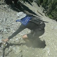
We parked at the big dirt turnout for Lower Monroe, which is a fun and popular local mountain bike route. We turned north and hiked down Upper Monroe to a point we decided looked best to begin the canyon. Sometimes you do the entire canyon from the real logical starting point, but often times locally this just means bushwhacking with no rappels or anything of value for quite some time. It's all bushwhacking around here as you all know very well so we kept hiking a little bit further before dropping in on a small gully feeding into the canyon. The bushwhacking was thick from the get go, and I got a stick right in my eyeball early on as a sort of welcome back by the canyon gods. I had my ESEE Junglas big knife, similar to a machete but much sturdier and shorter, which carries more momentum and works better against our dry wood out here. It usually makes short work of the bushwhacking we have here and is a bit better for small tasks as well (plus it's really cool and I'm a knife nerd). We did the usual crawling underneath dense brush as well as walking atop a false floor of interwoven vines and nonsense, and eventually it cleared up just a little and we could stand up and take a breath.
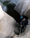
We met our first rappel a bit later...
Maybe 50ft or so of rope used. We brought two 200ft ropes. If I had the money I'd buy a 200ft pullcord to save a lot of weight and space. We try to keep things clean and conserve webbing and links as much as we can without compromising safety, so for the first anchor Amanda set up a CEM retrievable anchor, which uses only the rope, with three twists that surround a bight. Tension on the rappel line keeps the rope in place, and when one reaches the ground one pulls the retrieval side which pops the knots, and it all comes down. One must be careful to maintain proper tension and one should take care to keep the path of the rope free of snags, otherwise it would be easy for the rope to get stuck while pulling it down, as it comes down in a big loop. We had no such issues, and used this excellent technique later on. We had my old Canyonero rope and a C-IV on this trip. The Canyonero is very tough and has been used on many first descents showing minimal wear despite hard use for over a decade. It is very stiff, however, and handles as such unless it becomes saturated with water. The C-IV is much softer but also surprisingly durable, and we use that for the CEM system, as it is much more malleable. I wouldn't want to use the Canyonero for such things as it either may not hold the loops, or it would hold them so well it may not come down.
We continued down, bushwhacking at times but mostly enjoying the middle part of the canyon. I rarely take detailed notes on canyons, just noting approximate number of rappels as well as their length. In total we had 8-10 rappels, several downclimbs which perhaps should be rappels for some parties, and the longest single rappel was about 150ft.
That last photo shows the initial drop down what I figured would be the biggest rappel. I believe it still was, but not 200+ feet as somewhat 'expected'. When you see contour lines all smooshed together on a map or look at Google Earth data showing a loss of x amount of feet, you can either hit a massive rappel or cliff or find smaller ones bunched together. This was the latter. There was a short section of slab downclimbing beyond:
Having never been in this place before, I was enjoying the perspective. Everything felt pretty big around here. The local peaks were high enough above us and at just the right distance to feel so far away from home. It had a feeling similar to the western parts of Kings Canyon, before one sees any limestone or the granite big walls near Road's End. You can see Upper Monroe low center of shot, our hike out.
Several more rappels up to maybe 100ft followed. The possible 300ft rappel was a series of downclimbs and shorter rappels which looked larger from far away.
In this photo Amanda is rappelling off a small bush I wasn't super confident of. This is a short 40ft or so rapp to a small pool and cool little stance. A 60ft or so rappel is immediately afterwards, just to the right in the photo. We rigged our next rappel off the small Sycamore tree using the CEM method. I am above her with our second rope in case that Sycamore is dead. Since it's winter, the tree has no leaves so we don't know if its alive and solid or dead and would pull out. An acquaintance of ours rappelled off a tree elsewhere, which pulled out and he fell, shattering his ankle. His leg had to be amputated below the knee. It's fresh in my mind along with all the sketchy things I've done in the past so I am much more careful nowadays. The tree was healthy and solid, so I came down with the second rope and we continued on.
There are some real pretty sections of canyon such as above, with tiny ferns to include Maidenhair Ferns, mosses, Dudleya growing out of cracks everywhere, and we saw one salamander and one decent size frog. A beautiful hidden place in the mountains no other humans are likely to have seen. We only saw a couple metallic balloons!
Here Amanda rappels down one of the last drops. Shortly thereafter the technical section ends and we hike out a short distance to the road.
Here's a log with incut steps, likely placed by the residents of Fire Camp 19. It was solid, but very slippery. An easy way down. The road was just behind me in this shot and we took our gear off and started the hike out. The road is an easy hike but the mind wanders with such ease, often settling on thoughts of minor discomfort and a desire to be done already.
As one can see the water level is extremely high. That's the entrance to Burro Canyon range just right of center. Look how much water is under the East Fork bridge.
We got back to the car about an hour after dark and headed down to The Hat in Glendora for a big meal. We were both sore, having not done this sort of thing in quite some time. Canyoneering in the San Gabriels lesser traveled canyons requires crawling, digging, cutting, climbing, twisting ankles and getting poked in the face by all manner of plants, getting slashed at by those annoying thorny bushes, Poison Oak, falling through rotten logs, all the fun stuff. My back is still sore and I had a tiny chunk of meat ripped off the pad of one of my fingers which produced a surprising amount of blood which got all over the ropes and my pack. A great day doing an old favorite past time. I've got a couple more first descents on the radar, the next of which is extremely short and easy but quite cool looking from the road. This is a great time to do it as the temps are wonderful and there's enough water to make things fun but not overwhelming in any way.
Hope you guys are all having a nice time, getting out and enjoying the weather. Go do stuff. Remember, it's gonna be mega hot in no time and you'll be kicking yourself for not doing whatever it is you like out there. The world is full of excuses and comfort is hard to abandon. Just go do stuff.